

When it comes to new housing and infrastructure projects, cyclists have long complained of their lowly place in the pecking order of potential users.
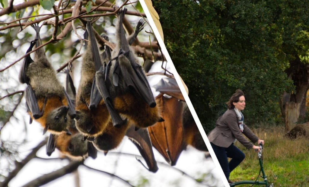
But in one new housing development in Bristol, people on bikes will fall below even bats in the hierarchy of road users, after a planned bat colony was afforded twice as much space as cyclists and pedestrians on an “incredibly popular” shared-use path which runs through the development.
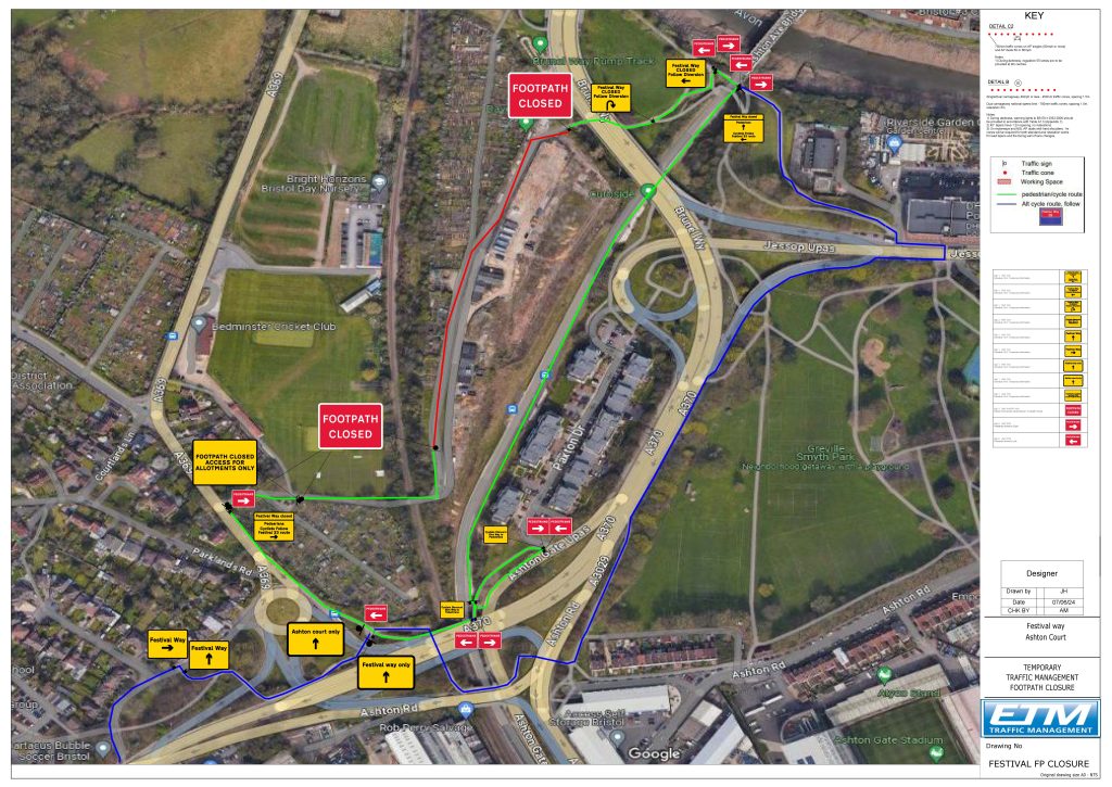
The decision to reduce the width of a section of the city’s Festival Way route, near the Brunel Way flyover, to just three metres has been made to accommodate a six-metre-wide bat corridor, which local cycling campaigners say will make the path “too narrow” for pedestrians and cyclists to use safely.
The narrowing of part of the traffic-free cycle route, which forms part of National Cycle Route 33 and is a key commuter route linking Bristol city centre to the North Somerset town of Nailsea ten miles away, is included in the Vistry Group’s plans to build 220 new homes at the City Gateway development, located on a former railway depot site at Ashton Gate.
The Festival Way path runs past the development but has been shut since May due to the ongoing construction work, with a route diversion and ‘cyclists dismount’ signs set to be in place until the end of January 2025.
Active travel charity Sustrans, which manages the National Cycle Network, has admitted that the signs calling for cyclists to dismount may make the diversion “difficult to negotiate” for some users, while also forcing them to use narrow pavements, and have apologised for the inconvenience.
Vistry says a “new cycle route” will be delivered as part of the housing project, and will include benches and “enhanced landscaping”, but local cycling campaigners say the scheme will narrow the existing path and create conflict between cyclists and pedestrians.
Last week, with the plans to narrow the City Gateway portion of Festival Way in place, the Bristol Cycling Campaign called on the local authority to reallocate at least an extra metre of space afforded to the bat colony back to pedestrians and cyclists before the development opens.
In a written statement submitted to a meeting of Bristol City Council’s transport policy committee on Thursday, Bristol Cycling Campaign chair Ian Pond said that the group “have been consistently concerned about the narrowing of the incredibly popular Festival Way to a 3m shared path along most of the section to accommodate the new ‘City Gateway’ development by Vistry Group”.
He continued: “We contend that this is too narrow and will create safety issues for path users when reopened.
“We ask that prior to work progressing further that BCC give urgent consideration to reallocating one metre of available space from the 6m-wide bat corridor and use it to increase the Festival Way to 4m-wide, in order to make the path safer for walkers and cyclists” – a compromise solution Pond acknowledged would still be “suboptimal” compared to the UK design standard of a two metre-wide footpath and a separated three-metre cycleway for shared paths.
“The time to act is NOW,” he concluded, “As widening the path after construction will be impossible once the bat colony has settled in their new home.”
> Six-year-old girl knocked over by cyclist on newly opened £2.1m Festival Way near Bristol
Responding to the campaign’s concerns, a council officer said that the width of both the proposed bat corridor and the shared path was agreed in 2021 as part of Vistry’s planning permission application for the City Gateway development, and that the council no longer had the power to step in.
“This issue was considered at committee and accepted on balance three years ago,” the officer said. “Unless the applicant sought to vary the planning permission, which would require consultation, there is no process available to the council to consider an amendment to the bat corridor.”
However, the chair of the transport policy committee, Ed Plowden, said that he would look into the issue in a bid to find some “wriggle room” for the developer to make the path wider.
“I am concerned about this,” the Green Party councillor told the campaign group. “I’m looking to see what wriggle room there is and contact the developer to try and make adjustments. I can’t promise anything, but I am investigating what wriggle room we have.”
This rather bizarre stand-off between a bat colony and cyclists and pedestrians isn’t the first time this week that cycling infrastructure has come into conflict with concerns for the local habitat.
On Tuesday, we reported that a residents’ group in the Glasgow suburb of Milngavie has urged East Dunbartonshire Council to put an “immediate pause” to a proposed five-mile cycle lane – as it has the apparent potential to threaten the “unique aesthetic of the area”.
The cycle lane is planned to be built along the Auchenhowie Road, connecting the A81 in Milngavie to the A803 at Torrance. The road itself is surrounded by acres of woodlands, described by residents in a Facebook video as “more than just trees – it’s a finely balanced ecosystem of open grassland and water features”.
The residents also have raised questions about the need for the bike lane, with concerns that no proper assessment of the current use or potential use by cyclists has been undertaken.
“Specialist reports into things like biodiversity that are needed on projects like this haven’t been completed. This is a heritage area so there are parts of the forest that are protected as ancient woodland and they are talking about taking away hundreds of these trees,” one resident said.
However, a spokesperson for East Dunbartonshire Council told road.cc that several drop-in sessions and a thorough online information campaign was held before the project was agreed upon, and that the infrastructure’s potential environmental impact has been carefully considered.
“Considering potential impacts on the wider environment and ecology plays a key role within the design development process and various surveys have helped to identify supporting actions the council and its contractors will be required to follow to mitigate any potential adverse effects,” the spokesperson said.


18 thoughts on “Bats to be given twice as much space as cyclists and pedestrians on “incredibly popular” shared path, as campaigners say new layout will be “too narrow” and “create safety issues””
Get on your bike, batman!
Get on your bike, batman!
Most of the shared-use path
Most of the shared-use path alongside the A369 from Pill to Rownham Hill (and the Clifton suspension bridge) is about 1.5 metres wide… Just sayin’
I admit to being a little
I admit to being a little confused: what were the bats doing before the huge development was started, when there was a shared-use path used by cyclists and pedestrians (as well as an area used by skateboarders)?
brooksby wrote:
…and why are the bats walking instead of flying?
If Bristol really does have
If Bristol really does have flying foxes, a 6m bat corridor doesn’t seem that unreasonable when you see the size of those things.
Although
– planned by who? The bats?
I thought bats were supposed
I thought bats were supposed to have top handling skillz and be capable of e.g. weaving through a charging peloton with ease – even after dark?
Surely the sensible thing to do is have a 9m corridor for those cyclists who are always wobbling all over the place, spontaneously falling off and crashing into things unaided by e.g. passing vehicles – and the bats will work round them? After all, even in formal Victorian attire aboard one’s high-wheeler you’re not going to need much more than 3 metres of headroom?
Even better: close the A370
Even better: close the A370/Brunel Way to motor vehicles and give that to the bats. No-one drives on that road, because there is too much traffic.
Has this come straight from
Has this come straight from the 24/7? Or perhaps an inner page of the Post?
Dagnammit, I created a forum
Dagnammit, I created a forum post for this topic (mainly just so that I could post this image)
Bats complained but there was
Bats complained but there was no response by the council and developers. “It was like they literally couldn’t hear me”, squeaked a pipistrelle. “Plus their offices were never open at any reasonable times e.g. after dark”.
I never used to understand
I never used to understand how bats could see their way around at night, but then it clicked.
hawkinspeter wrote:
Good ‘un – but funnily enough bats see very well at night, their night vision is significantly superior to that of humans even without their echolocation capacity. I only discovered this recently and have been boring people with it ever since so I don’t see why you should be spared.
.
.
Bats are rather interesting.
Bats are rather interesting. 20% of mammal species are bats. They have rather odd immune systems. And they have adopted similar metabolic strategies to birds, that convergent evolution at work there.
I wonder whether they have their echolocationary info mapped onto their visual image?
There are blind people who use clicks to navigate their world, one I’ve seen on telly riding a bicycle around a park, who as I recall “see” using this technique, one that can be taught and learned.
ktache wrote:
That I did not know, thank you!
One of the reasons Adam West
One of the reasons Adam West got the part of Batman was because he didn’t burst out laughing when he read the script at his audition.
UK planning, council officers
UK planning, council officers, Highways England and LA highway officers have the incredible ability to present utterly flawed low-standard 5h1te cycle infrastructure despite having access to best practice examples across the Netherlands. Is it cultural stupidity?
Ah but they’re only best
Ah but they’re only best practice in NL! The UK is a completely different country. We have different laws, hills, narrow streets, weather, people just don’t cycle here anyway, cyclists here often threaten pedestrians, and frankly we just aren’t Dutch.
There are nuances – some actual laws apparently get in the way of some designs. We don’t (or didn’t until recently) have handy suppliers of some of the bits of infra (see e.g. Ranty Highwayman on sloping kerbs).
However given we’ve had a system which has increasingly pushed money towards motor transport, which has been in place for a few generations, and where everyone from politicians through councillors, planners, roadbuilders to plain proles has taken this as a given (indeed a good) … this is entirely to be expected.
It’s not just that we don’t know the details. Our overall philosophy and goals are at odds with those in the Dutch system. We look first to maximise safe motor traffic capacity, and then ensure safety for others. Because motor capacity and convenience come first (and are what all the money is for) we then get safety for other modes at the expense of convenience. Or “there isn’t space / money / the staff” to care about their convenience at all. (There are other details as well about organisational structures and responsibilities which are more subtle but may ultimately be important to “why NL is as it is”).
We literally have car-brains – our thinking tools involve (private) motor transport as a primary part of transport problem-solving. Our organisational structures and knowledge will be built around this (especially planners, builders etc.) Never mind this is also part of our position in society, our “competent, independent adult” status etc.