

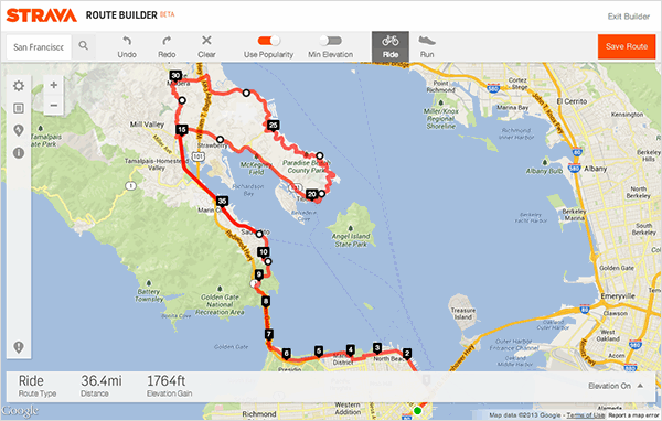
Strava has just released its new Route Builder feature, which is free to all members. The online route mapping market is a crowded one, but Strava’s trump card is being able to use the millions of activites that have been uploaded to let you see which roads and paths are popular in any area, and include them in your route planning.
A quick poke around reveals it works like any good route mapping tool, it’s easy to use with clear instructions presented when you first sign in. Plotting a route is as easy as dropping waypoints on roads you want to ride. It shows your distance and elevation and, using your average speed from the past four weeks, will calculate a ride time.
But the really neat bit is the Use Popularity function, which overlays the map with the most popular roads ridden by Strava members. It allows you to see which roads are really popular in your local area, so you can plan those into your route. A small leap of imagination sees it being useful for exploring roads away from home, say if you’re visiting another part of the country, or even going on holiday.
There is plenty of other interesting functionally too. A curious one is the Minimise Elevation, which is fairly self explanatory. How about a maximise elevation option Strava?
When you’ve finished building a route, you can download it to a GPS device or share it with your Strava followers, Facebook friends and by email. You can also print cue sheets of your route, which is handy for longer adventures and touring.
Head over to www.strava.com now to check it out. And while you’re there, don’t forget road.cc has a Strava club.


20 thoughts on “Strava launch Route Builder”
I think it’s been there for a
I think it’s been there for a good week or so now. The lack of ‘maximise elevation’ struck me too. I’d have thought that would be more appealing to most Strava users.
Woohoo… not really that
Woohoo… not really that different to others but all on one site 🙂
The routing is full of bugs
The routing is full of bugs or the underlying data is quite poor, last I checked – at least around me in Scotland. There are roads it refuses to go down, junctions which it doesn’t seem to think exist, etc.
This could be the killer blow
This could be the killer blow to Garmin connect – route planing the only reason I used it.
i knocked up a quick route
i knocked up a quick route round bath/bristol and it sent me down the A38 past bristol airport – can’t imagine that’s very ‘popular’ 😕
that aside, it chose a lot of the same roads that i would.
I’ve used the beta for a bit.
I’ve used the beta for a bit. Works nicely on roads around Hertfordshire, and it’s never sent me off down motorways, dual carriageways or anything stupid. Only problem was when I tried to build some routes around Denmark for summer hols. Wouldn’t let me turn left at some junctions, when in reailty I could.
It’s been there for over a
It’s been there for over a month, nice to see you guys are on the ball !, its also good to see they finally added a Delete Route option, I’ve had some test routes on my list for bloody ages ! finally I can get rid of them
mikeprytherch wrote:It’s been
It was only available to premium members at first. As of today it’s available to all members. Now who looks silly
I’m not a premium user and I
I’m not a premium user and I used it last week for my ride last Sunday.
Now who looks silly?
In all seriousness though, I would love to see my routes available on my smartphone, I don’t think that’s too much of a leap.
David Arthur
I’ve been a premium member fora while now..not for the ‘benefits’ but because I’ve had great service from their help desk…and someone has to pay their bills. It’s a bit like the irratition I feel as a MTB rider when I go to a trail centre and see all those riders with £3&£4K bikes parking on the roadside to avoid paying the single digit parking fees..cheapskates ~X(
Buggy around side roads; a
Buggy around side roads; a half baked attempt. Strava is skimping on innovation, skimping even on servers now.
Oh, well now I do look
Oh, well now I do look silly
My initial impression with route builder has faded – it doesn’t want to route out of my estate without going down the dual carriageway and the long way around town way, rather than the half mile road to the country lane at the end, which is really annoying. Think I might just stick to bikehike
Just pulling your leg a bit
Just pulling your leg a bit mate, slow Friday at the office! I found it a bit stubborn as well, but you can bend it to your will, maybe change your starting point if you know the area well anyway.
Been using it in for a while
Been using it in for a while now, no problems whatsoever. Only thing that would make it slightly better for me is the ability to do street view like some of the other route sites. Couple of times I’ve ended up on farm tracks (which looked like normal roads on the map) because I haven’t checked street view first!
It’s nice. I like that it
It’s nice. I like that it uses my average speed to estimate times, though I’ve been riding a lot on the cargo bike with trailer recently so that average speed is low. It would be good if it allowed me to specify which bike I’ll ride. Things can improve, and Strava have the data to do some very good estimating. I hope to see this weekend how well it works with the Garmin 510 for navigation.
I’ve been using RideWithGPS until now.
I’ll apologise in advance to
I’ll apologise in advance to roadies in the Nottingham area who will get sent down my off-road commuting routes – I’ve racked up a few hundred rides down them single-handed which may skew the popularity figures somewhat!!
I am not certain, but I think
I am not certain, but I think the ‘heatmap’ function works using segments only. Therefore the it may not ‘see’ or pick the most popular routes, but the most popular segments.
Virtually unusable – I asked
Virtually unusable – I asked the route to go from A to B linked by a road (about one mile) it either went on the adjoining road or put in a 7 mile detour.
elevation data was way off in
elevation data was way off in the Alps, 5000+m compared to 3600m recorded on my Garmin.
Nice additional features that
Nice additional features that increases the usability of the Strava package. No need now to use a second program for route building and Strava for tracking