

Komoot is both a desktop and a mobile app, with most of the features available through either portal, and navigation based on your smartphone, either using the screen for mapping or an earpiece (or the speaker) for turn-by-turn instructions, or both. It offers something a bit different to the other options out there, with a lot of curated content, and a more sophisticated routing engine. It’ll appeal more to those who mix road with gravel and mountain biking (and maybe a bit of hiking) than out-and-out roadies, but for those people it does enough to justify the price, especially as it’s currently a once-for-life payment.
- Pros: Routing has useful features, offline mapping and navigation, voice guidance works well
- Cons: Highlights only as good as the people creating them, curated content hard to navigate
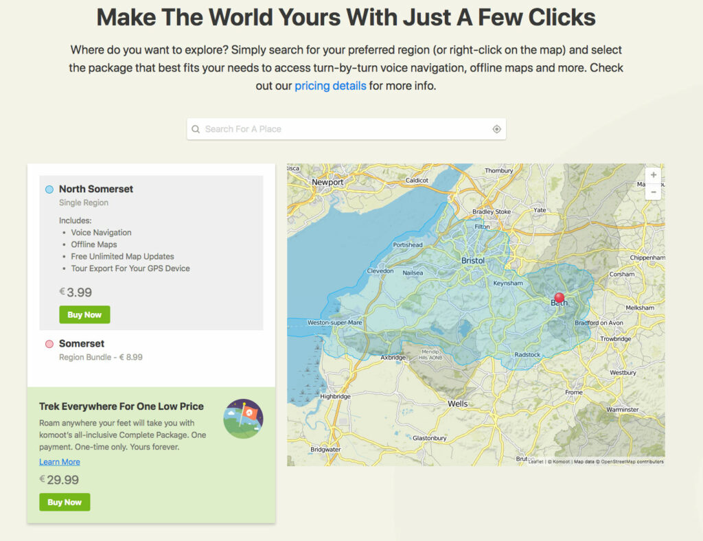
To use Komoot you’ll need to unlock some mapping. You get one ‘single region’ for free, which is fine for trying out the platform but it’s not a huge amount of use for ongoing road riding. You can buy more single regions for €3.99, or ‘bundle regions’ for €8.99, but realistically the spend here is currently €29.99, which buys you the whole world, for online and offline use, forever. Those other region-based options would soon work out very expensive, unless you never leave your local area.
There’s talk of Komoot moving over to a subscription model, so if you’re thinking of taking the plunge then sooner rather than later is probably the call to take advantage of the once-only fee.
Routing: lots of options, lots of curated and auto-generated content
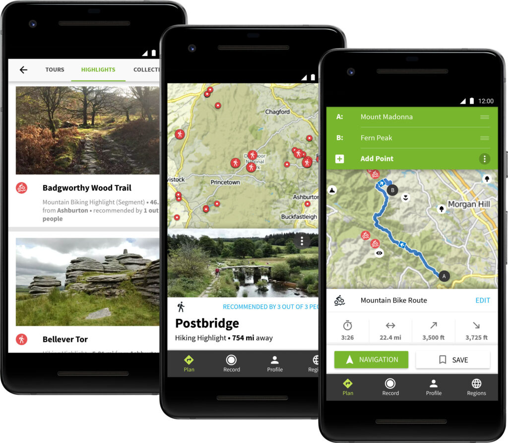
Route planning on Komoot is powerful, although like all platforms it’s not without its foibles. You can choose to plan a road bike, touring bike or mountain bike route; you can toggle between them at any time and Komoot will re-jig the route. Not surprisingly, the road cycling routing sticks to bigger roads (it’s not shy of an A-road), the touring routing favours smaller lanes and some unsurfaced sections, and the mountain bike routing stays off road as much as it can. If you’re keen on walking then there’s routing for that as well.
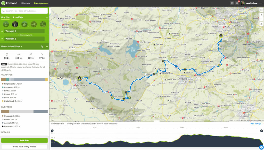
The routing is pretty sensible. Like with any routing app you’re at the mercy of how good the basemap information is, but mostly I found Komoot making similar choices to the ones I’d pick on routes I knew. It’s not shy of spending some time on A-roads in road cycling mode, so if you prefer a quieter loop then bike touring is a better option. That being said, you need to be a bit careful that it doesn’t route you and your Sunday best bike down some bridleway halfway round.
Set to bike touring mode, the routing algorithm is pretty good at sniffing out interesting lanes, too: on a few occasions it’s routed me down lanes or paths that I didn’t know about and turned out to be excellent alternatives to stuff I’d more usually choose. Sometimes the routing for gravelly and mountain biking stuff strays away from what’s technically legal: the odd footpath, the odd unclassified path that you may or may not be entitled to ride. It wasn’t a huge issue though.
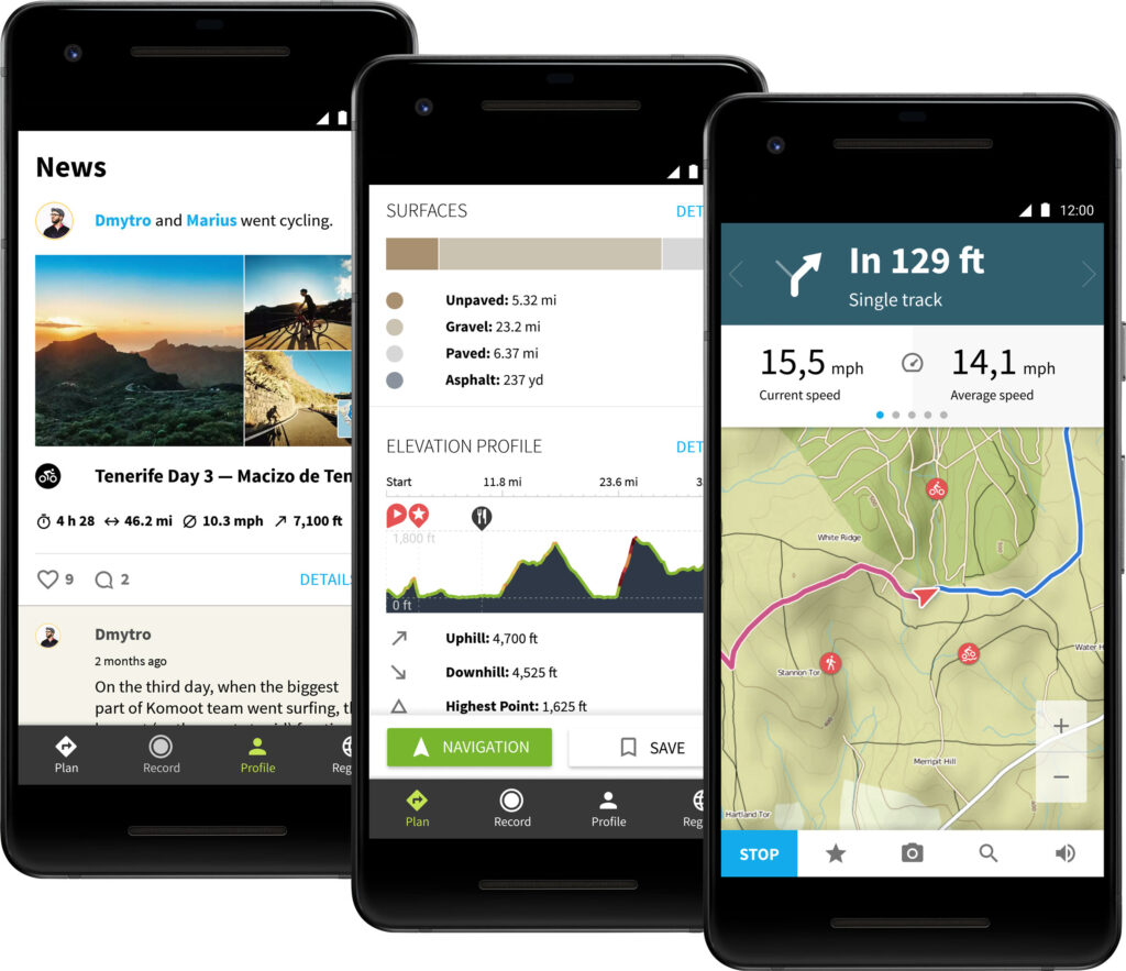
Komoot has an extra trick up its sleeve that you don’t get on Strava and other routing apps I’ve tried. When you’re planning a route it gives you a breakdown of the different surfaces around the route, and you can highlight the different surfaces on the map as you plan. So if you’re creating a road route somewhere you don’t know, and you notice that it has some unsurfaced sections, you can check on the map to see where they are and re-route if you want to. That’s pretty handy, and it means you’re less likely to get caught out. On the flip side, if you want to favour unsurfaced bits but still make it mostly a road ride then it can help you do that too.
You can choose from Komoot’s own basemap, OpenCycleMap, OpenStreetMap, Google Maps and Google Satellite. OS mapping would be a great addition for checking the off-road bits.
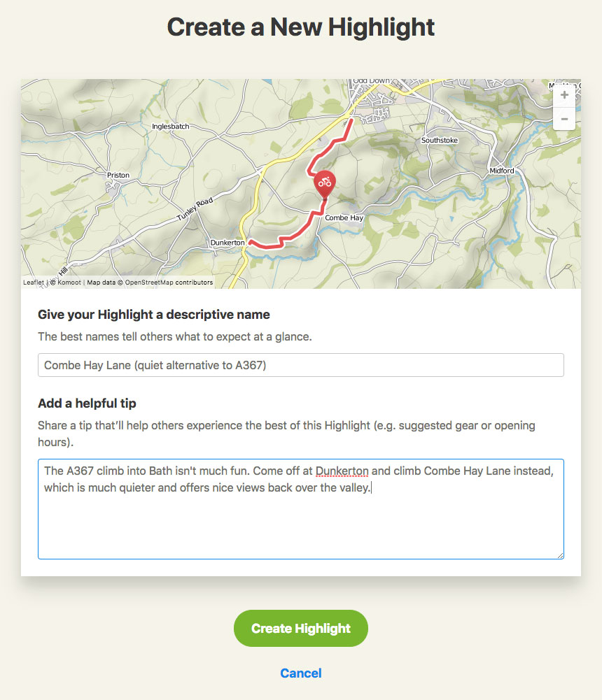
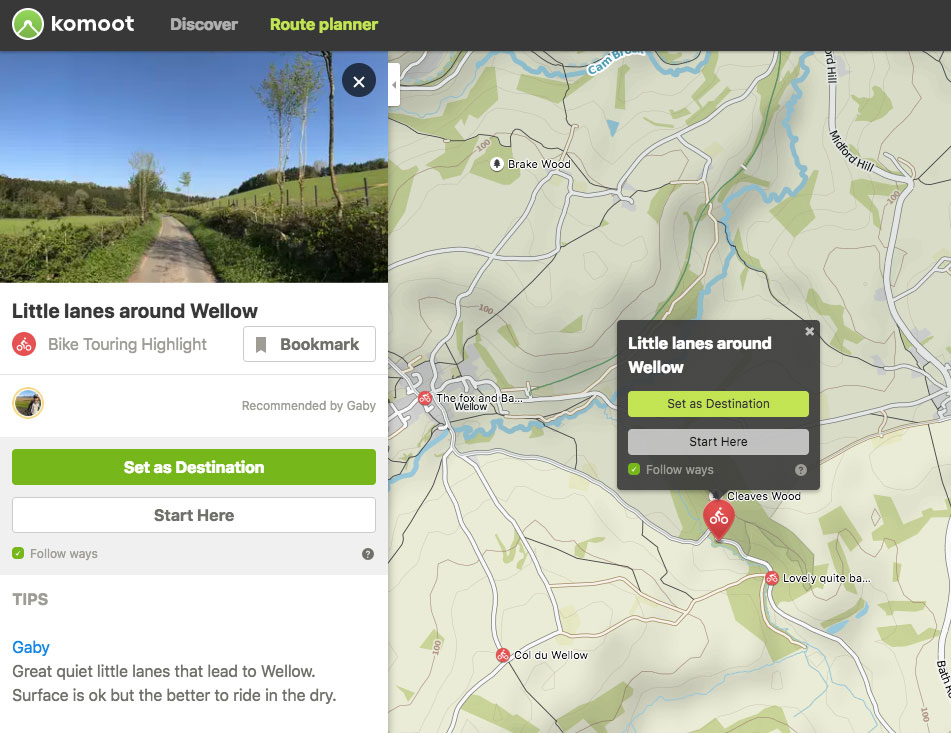
The process of creating a route is designed to an extent around highlights that users are encouraged to add to the system. If you’re planning a route somewhere you don’t know, then you can have a scout about for interesting things to see, and ask Komoot to plot a route that includes them. Some of the POIs are just points, and some are sections of route that you can include on a loop or a day ride. If you add a few POIs then Komoot will work out the most sensible order to include them.
The whole system works pretty well; you can find interesting places and create meaningful tours to include them. At present there isn’t a huge number of highlights around our local area; the quantity (and quality) varies depending on where you are in the world and who’s adding them. You can add your own by selecting a ride that you’ve completed and choosing either a segment of the ride or a point to highlight. You get to add a title and description, and photos if you have them. The fact that you need to have ridden either past or along a highlight adds a bit of rigour to the system, but is also probably the reason there aren’t so many highlights right now.
How Komoot manages the growing database of highlights in the future will be a big factor in how useful and how usable the system will be. Too many highlights and it might become hard to find the wheat among the chaff. There’s a recommendation system, so if you’ve planned a route to include a highlight you can recommend it, and there are different levels of user, so in theory you could filter the highlights to only see recommended ones, or ones added by someone with a good rep. At the moment there doesn’t seem to be a way to do that.
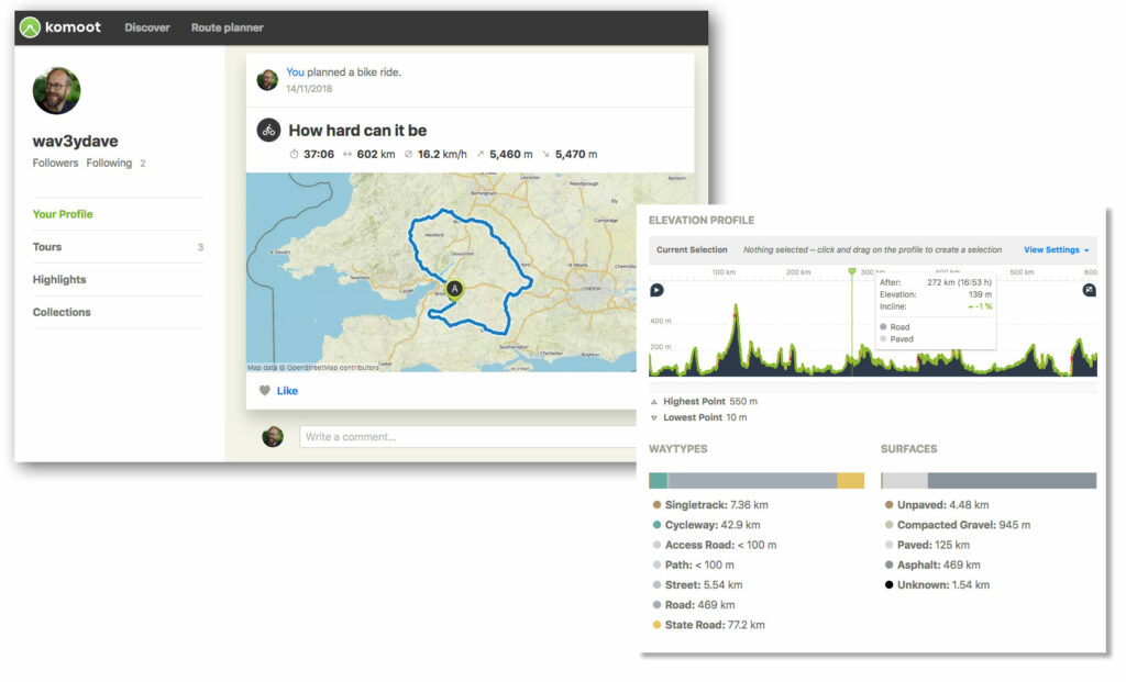
Komoot auto-generates routes, taking a series of highlights in a region and knitting them together into rides. It does a pretty decent job of it too, provided there are enough local highlights to link together. Around Bristol and Bath there are enough for a decent number of automatically created options; in other places I regularly ride, such as the Peak District, there aren’t really enough to get the job done.
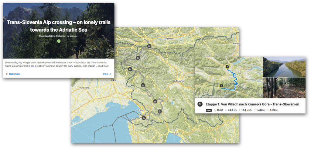
Komoot also has collections, which are curated, erm, collections of routes. They certainly add another layer of depth to the whole Komoot ecosystem, and there is a lot of good content on there. If you’re looking for something like a multi-day tour then there’s everything from bikepacking across Wales to mountain biking in Thailand to pootling along the Loire. It’s not particularly easy to find stuff, though, and I’ve found myself hunting around for collections I’ve seen but subsequently been unable to rediscover on a couple of occasions. There’s a location-based search but the app could also do with a keyword/discipline type search too.
Navigation: if you like to be talked around, it’s the best
Once you’ve created a route, you’ll be off to ride it of course. If you’re navigating a route you can opt to download everything you need beforehand, so that you’re not dependent on a mobile signal to get you round. That’s very handy if you’re anywhere remote, and saves on data charges (and battery use) if you’re not.
So far as navigation goes, you can use the Komoot app on your smartphone and fix the smartphone to your bar, assuming you’re okay with it being there. The map view and directions are pretty clear. You do have another option too, which is voice navigation. A few apps I’ve used – OSMAnd most recently – have offered this as an option, but Komoot is the first one I’ve used where the voice navigation is reliable enough to actually get you round without any real issues. You get clear instructions, road numbers and names, exit numbers at roundabouts and (mostly) plenty of warning about upcoming turns.
> Buyer’s Guide: 15 of the best cycling GPS units
Clearly, you’ll need something to play your voice guidance. I used a cheap bluetooth earpiece which worked pretty well: you can have turn-by-turn directions in one ear and keep the other for hearing your surroundings. Sometimes when one turn closely follows another you don’t get much warning, and sometimes Komoot tells you a turn is coming up when really it’s just a bend in the road, but that’s better than the alternative (which OSMAnd is terrible for) of not giving you enough instructions, and missing forks and junctions.
Overall, the navigation is really good. If you like being guided round then it’s definitely one of the better map-based systems I’ve used, and it’s the best for voice guidance on a bike.
Integration: it feels like Komoot doesn’t want to play with the others
Komoot allows you to search your Facebook friends and hook up with anyone who’s on the platform already, and you can also email invites out to your friends if you want them to join. You can sync Komoot with Garmin Connect, so if you’re using that platform your rides will also show up in Komoot. What you can’t do is sync Komoot to any other platform such that rides you record in Komoot will show up elsewhere.
I use Strava to do all my mile logging, as it can sync with lots of different platforms – Zwift, TrainerRoad, The Sufferfest, Garmin Connect, Bkool and so on – for both indoor and outdoor riding: it’s nice to have everything in one place. I know I’m not alone in doing that, and it’s a fairly major omission on Komoot’s part to not have that functionality available to those who want it. You can still sync rides, but it’s a manual process: download a file from Komoot and re-upload somewhere else. If you solely ride outdoors then you could switch over wholesale to Komoot, and to be fair it’s designed as an outdoor tool, but realistically that ship has sailed for a lot of road riders, and if you do any indoor training you want to keep tabs on then Komoot can’t help you there.
Even if you do use Strava for everything, Komoot is something I could recommend from a routing and navigation point of view: the routing is a bit more fully featured than Strava, and the turn-by-turn navigation is the best of the bunch.
Overall: if you’re outdoors-bound, it’s a solid choice
Komoot says that it ‘makes it easier for you to experience authentic outdoor adventures’ and that’s certainly true. There’s good routing, a heap of curated and automatically generated content, and when you’re out and about the navigation is very good, with the voice turn-by-turn the only one I’ve used that really does the job on the bike. For a single one-off payment that’s less than a new front tyre, it’s a decent investment.
Verdict
A powerful routing engine and good turn-by-turn navigation
All the deals displayed on our review pages are pulled from a constantly updating database feed of the best affiliate deals available. The criteria for deciding on what are the best deals is who is offering the lowest, delivered price. In most cases we will be showing the very best deal available online, but sometimes you may be able to find an item cheaper. If you can please feel free to post a link in the comments box below. To find out more about affiliate links on road.cc click here.
road.cc test report
Make and model: Komoot app
Size tested: n/a
Tell us what the product is for and who it’s aimed at. What do the manufacturers say about it? How does that compare to your own feelings about it?
Komoot says, “Komoot makes it easier for you to experience authentic outdoor adventures. Whether road cycling, hiking, bikepacking or mountain biking, komoot’s superior planning and navigation technology allows you to easily discover more of the great outdoors.”
Tell us some more about the technical aspects of the product?
From Komoot:
A Better Planning Tool
Build your perfect outdoor experience using the world’s best outdoor tech
More Intuitive Navigation
Turn-by-turn navigation and offline maps keep your adventure on track
A Log of Every Adventure
Save every adventure and share your experiences with your friends
Plan The Perfect Route
Whether you want smooth asphalt for your road bike, single tracks for your mountain bike or peaceful trails for your hikes, komoot generates sport-specific, topographic routing”tailor-made for your next outdoor experience. Simply customize each route to include whatever you want to see along the way, and view inch-by-inch surface and way type readings to ensure you always know what’s coming”wherever your adventure takes you.
More Effective Navigation
No matter how secluded the path or how off-road the trail, komoot’s turn-by-turn voice navigation will ensure you’re always going where you’re supposed to be”without ever distracting you from your surroundings. And as the great outdoors never comes with strong signal, everything works offline. Just conveniently download individual routes or entire maps for use offline, and stay on course when coverage falls short”no matter how off-grid you go.
Every Outdoor Memory. One Story.
Do something awesome on your last trip? Tell the world about it. Share photographs and stories of your adventure’s best moments, recommend your favorite spots to the komoot community, and surround yourself with like-minded adventurers”even when they’re a mountain range away.
A decent investment given that it’s a once-only payment for everything for ever.
Tell us how the product performed overall when used for its designed purpose
Very well: good routing and navigation, lots of content.
Tell us what you particularly liked about the product
Routing is powerful, navigation is good, offline mapping and navigation.
Tell us what you particularly disliked about the product
No Strava or other portal integration, content sometimes hard to browse/find.
How does the price compare to that of similar products in the market, including ones recently tested on road.cc?
Strava Summit is the best part of £50/yr, although it’s doing a different job to this. RidewithGPS is $50 a year for voice nav and offline mapping. A one-off payment of €29.99 seems like good value to me.
Did you enjoy using the product? Yes
Would you consider buying the product? Yes, especially for a once-only payment.
Would you recommend the product to a friend? Yes
Use this box to explain your overall score
It’s a good ecosystem. It’s not without its foibles and it’s a shame it doesn’t play nice with Strava from a road cycling point of view, but if you’re interested in cross-discipline routing and navigation, it’s probably the pick of the bunch right now.
About the tester
Age: 45 Height: 189cm Weight: 92kg
I usually ride: whatever I’m testing… My best bike is: Kinesis Tripster ATR, Merida Scultura
I’ve been riding for: Over 20 years I ride: Every day I would class myself as: Experienced
I regularly do the following types of riding: road racing, time trialling, cyclo-cross, commuting, touring, club rides, sportives, general fitness riding, fixed/singlespeed, mountain biking, Mountain Bike Bog Snorkelling, track


7 thoughts on “Komoot app”
The only thing holding this
The only thing holding this app back for me is that you can’t set privacy zones. It’s a long-standing feature request (like 3+ years) so I guess it’s not something that can be added easily. It’s a shame because it means I can’t share my local routes without remembering to start and stop rides away from home.
You can now.
You can now.
https://releasenotes.komoot.com/new-range-of-privacy-settings-let-you-control-how-you-share-on-komoot-36XVVC
I would like this too but I
I would like this too but I usually remember to just start and stop the ride at the end of the street.
How does it know whether a
How does it know whether a road is paved or not? I prefer to ride gravel(once they are firm enough) rather than paved roads, but normal google maps and others don’t show whether or not a public road is paved. Gravelmap.com addresses this by having users mark section as gravel as an overlay on the website, but as far I know,you can’t import that information into another navigation app like Komoot, even if there are enough local gravel riders in your area to have marked it up comprehensively.
Tjaardbreeuwer wrote:
Most likely from the openstreetmap project: https://wiki.openstreetmap.org/wiki/Key:surface
Thanks for the heads-up on
Thanks for the heads-up on the move to a subscription model. Was going to pay for the world map at somepoint. Done now. I find it really useful getting round the London area.
I started using Komoot
I started using Komoot because it provided turn-by-turn navigation with my Wahoo Elemnt. I exported my existing Strava routes as GPX files and imported them into Komoot and I can now select them from the Elemnt (actually I could do that with them still in Strava IIRC, but not with turn-by-turn navigation).
Its route planning is up there with the best, and the maps are great – maybe not Ordnance Survey level, but way better than Google Maps for finding bridleways when out riding or walking.
Comments are closed.