

The London Tube map app produced by Bappz has had a map showing the city’s Cycle Superhighways and Quietways added.
BikeBiz reports that the London Tube Map app started out in 2009 as the first free Tube map application for the iPhone.
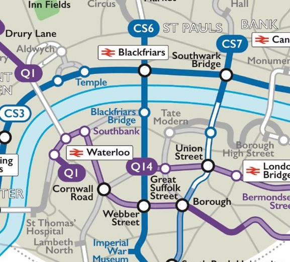
An Android version has followed and it has been regularly updated with additional features since. The latest innovation is a cycle map screen that uses GPS to display the nearest cycle routes, letting the user know how far away they are.
Paul Myers, the firm’s founder, commented: “With summer coming and the onset of a host of dockless cycle hire services like Ofo, Mobike and Urbo adding to the Santander Cycles scheme already well established, London is becoming a genuine bike riders’ city.
“This summer is set to be pivotal point for London commuters and in particular cyclists, with app-managed bike hire services, affordable e-bikes having exponential record sales growth and TfL’s Cycle Superhighways and Quietways becoming a legitimate cog in London’s transport infrastructure future.”
He added that the design of the map was influenced by Harry Beck’s original London Underground map and so would feel familiar to users.


2 thoughts on “London Tube map app now also offers a cycle map”
Can’t seem to find it in the
Can’t seem to find it in the Android app (which appears to have been written c. 2012). Much prefer TubeMap from Mapway, although that doesn’t list CSH/QWs
Or just follow an ordinary
Or just follow an ordinary road map.