

A cycling and walking group in Cambridgeshire has criticised “fourteen years of inaction” by the local council after persistent flooding on “what should be an exemplar active travel route” has forced cyclists and pedestrians to create a makeshift path “dangerously close” to a controversial guided busway.
The maintenance track which runs along a section of the Cambridgeshire Guided Busway between Swavesey and St Ives is prone to seasonal flooding, a problem local campaigners say has grown worse in recent years. As a result, Cambridgeshire County Council, which runs the busway, has closed sections of the path and warned cyclists, walkers, and wheelers to avoid using it.
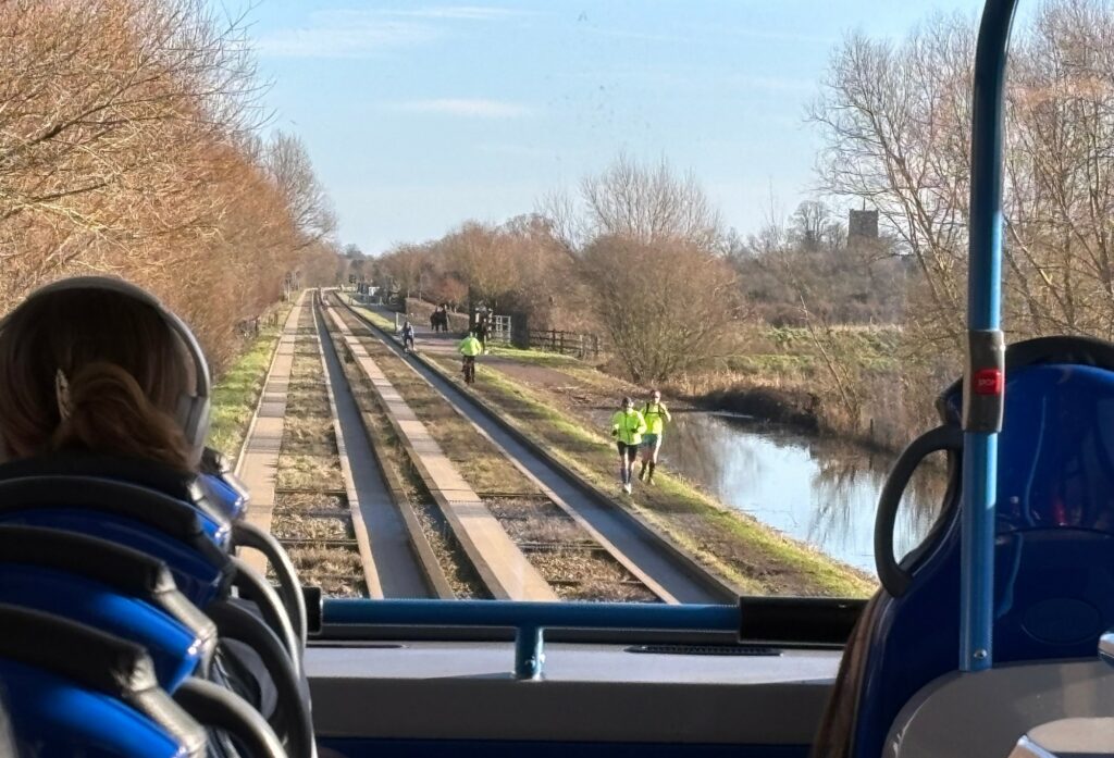
However, the path’s perennial closure has led to locals creating an informal path to avoid the water, which is extremely narrow, often muddy, and slopes towards the flood, and runs extremely close to the busway’s tracks – while one local has claimed that he has seen several cyclists riding on, and even walking along, the tracks, “holding up buses” in the process.
The Cambridgeshire Guided Busway, established in 2011, is a rapid transit system connecting Cambridge, Huntingdon, and St Ives using old rail lines, and at 16 miles constitutes the longest guided busway in the world.
However, the scheme has been marred by safety concerns following the deaths of two pedestrians and a cyclist in three separate incidents. In September 2018, cyclist Steve Moir was killed when he clipped a kerb on the shared path that runs along the busway, close to Clare College sports ground, and fell into the path of a bus.
Earlier this month, as part of an independent review into the deaths, Cambridgeshire County Council offered a “profound apology and contrition for the serious and systemic failings” which led to the three fatal incidents, along with another collision which left a boy with life-changing injuries, but pointed that as the busway was a “novel transport system”, there “were no national design standards, only recommended practices”.
> Family says authorities “aren’t really bothered” that cyclist died on Cambridge guided busway
And now, John Morris, leader of the Hunts Walking and Cycling Group, has called on the local authority and the Environment Agency to address the persistent flooding problem along the maintenance track “before we have another fatality”.
“People walking or wheeling have over the years created an informal narrow footpath along the top of the embankment to bypass the flood section of pathway,” Morris, who represents the 2,300-strong group, said this week, the Cambridge Independent reports.
“This informal narrow path is dangerously close to the guided busway track. A solution to the seasonal flooding must be designed and delivered before we have another serious injury or fatality on the guided busway.
“Fourteen years of inaction on what should be an exemplar active travel route between St Ives and Cambridge is simply not acceptable on this critical greenway used by many thousands of commuters and leisure users each year.”
Meanwhile, one local who uses the busway has said that he has witnessed a number of cyclists using not only the makeshift path, but also the bus tracks along the flooded section, posting a photo of one such occurrence on BlueSky earlier this year:
The bus user, who goes by the name Big Ron on BlueSky, also claimed that he has seen “cyclists literally walking their bikes down the busway, holding up the buses, presumably in protest against the flooded path”, a practice he described as “blood boiling”.
Earlier this year, the council installed signs along the flooded sections of the busway, urging locals to avoid using the path, and prompting one local to write on Facebook that “the Dutch wouldn’t have made this rookie error” concerning active travel design.
“The guided busway maintenance track, the path which runs alongside the busway, is closed in parts between Swavesey and St Ives to the public due to flooding,” a Cambridgeshire County Council spokesperson said this week.
“Just before this section, there is a gate which has closed the path and a sign which clearly states ‘flood, path ahead closed’.
“We would urge people – do not try and walk along the busway while it’s flooded. We are actively looking to resolve the flooding issue at this location so that it remains open all year.”
Of course, the track running alongside the Cambridgeshire Guided Busway isn’t the only active travel route in the UK prone to long closures thanks to persistent flooding.
In Bath last year, cyclists criticised the apparent lack of attention afforded by local authorities to active travel infrastructure, after it was confirmed that a tunnel which forms part of the National Cycle Network and provides a key commuter route for local cyclists was closed once again due to flooding – just over a week after reopening briefly for the first time in three months.
Opened in 2013, the Devonshire Tunnel is part of Bath’s Two Tunnels route, a shared-use path frequented by commuters and leisure cyclists seeking to avoid the city’s hills.
However, heavy rainfall in the area over the 2023 Christmas period, which overwhelmed a nearby damage drain currently awaiting repair, led to the tunnel being severely flooded and almost impassable by bike, with cyclists noting the presence of “large objects invisible below the water”, and Sustrans admitting that attempts to solve the drainage problem “could take some time”.


53 thoughts on ““14 years of inaction”: Cyclists accused of walking on tracks and “holding up buses” in protest at constant flooding on active travel route, forcing users to create DIY path “dangerously close” to controversial busway”
It’s hopefully an urban myth
It’s hopefully an urban myth but I heard it was designed that way on purpose, so the cyclepath captured any flooding and the busway would remain clear :-/
I believe it’s an urban fact
I believe it’s an urban fact that there are zero cycle infrastructure experts employed in the UK.
This is why we can’t have
This is why we can’t have nice things.
The temporary answer is to build a scaffolded walkway along and over the flooded path. That would probably take a day to do, would be perfectly safe, and would prevent another death whilst also keeping the buses moving. This isn’t rocket science.
Exactly. There must be a
Exactly. There must be a special training course in local government called ‘how to spend taxpayers’ money on doing nothing’.
I’ve worked in local
I’ve worked in local government before and some really don’t need any training for that – they’re already masters!
KiwiMike wrote:
That was my first thought. I’m not familiar with the route, but if the flooding really isn’t that deep, but it is a recurring issue that isn’t close to being solved, then the next time it’s dry-ish – get some kind of temporary walkway in place.
It would need a bit of planning, and someone to approve spending money on a cycle path, but I don’t believe that it’s particularly difficult from a technical point of view. And let’s see a plan for unclogging and repairing the drainage.
Then it sounds like they need to raise the levels of the path at the areas that cause most problems.
Out of curiosity, what
Out of curiosity, what options do you have if you get – say – halfway along there and then find that it is closed due to
incompetent civil engineeringflooding? Do you have to go all the way back and take an alternative route? How much distance would that add to a journey?Miles, plus one of the
Miles, plus one of the alternatives is concrete slab road. So yes you are supposed to turn around.
The flooded section is gated off quite a way ahead, and warns of fines for going past the gates. The worn path next to the busway really shouldn’t be used due to the speed of the buses.
There’s a FB group where people post passability updates and a Strava one (updated less regularly). The water levels have dropped but that’s taken months.
The worst, most continuously flooded section, is by the lakes and it’s partly due to drainage culverts not being maintained.
MsG wrote:
No the answer is to stay off the busway, fence it or use an alternative route.
Not acceptable. If the A14
Not acceptable. If the A14 was blocked like this and I said ‘find an alternative route’ you’d rightly reply with some choice Anglo-Saxon expletives.
It was stupidly designed as a service road by utterly incompetent travel planners who, in absence of any active travel thinking, decided no-one would cycle that far. 🤦🏻
I cycle next to Austrian railways with no barriers, on perfectly smooth, flood-free greenways and there are a fraction of the incidents we have, over far longer distances.
We are an incompetent nation.
We can’t build infrastructure properly. We’re f00kwits glued to our phones while walking with cyclists. We put dogs on near invisible leads that extend across cycle paths, we ride at TT pace past small children and dogs (on invisible leads), and our arrogant car-is-king culture is the most toxic on the planet.
You can find me to chat further, with a shovel, digging a f’ing ditch at the flooded portion of the misguided farceway.
You won’t find anyone in local government doing anything competent with anything to do with cycle infrastructure.
Tip top mate, tip top
Tip top mate, tip top
Where did I say it was ok to
Where did I say it was ok to use the busway itself or that path on the track?
I do use an alternative route and have done for months. Actually.
Quote:
After three fatalities and a serious injury it shouldn’t require national design standards to figure out that some form of safety barrier between the path and the busway is required.
Rendel Harris wrote:
After three fatalities and a serious injury it shouldn’t require national design standards to figure out that some form of safety barrier between the path and the busway is required.
A barrier doesn’t address the underlying issue of the path flooding – that’s what needs to be fixed
hawkinspeter wrote:
No, it needs a barrier like the railway.
It needs to be fixed but
It needs to be fixed but there’s no indication that any of the fatalities were caused by people avoiding the flooding; in the case of the cyclist killed it definitely wasn’t, he was on the path, tried to avoid pedestrians, clipped the kerb and fell in front of the bus (story here). As can be seen from the photograph below, a moment’s innattention or slip from a pedestrian or cyclist could end up with them going under a bus, even a small barrier could prevent that.
Difficult to use that term “a
Difficult to use that term “a moment”s inattention” when we berate so many other road users for over simplyfying the cause of the incident as the expect the leniency of the court.
These are design flaws. The incident is primed to occur at the design and execution stage, it is baked in, it isjust wating for a trigger event.
A single failure in a safe system should not lead to death, there must be mulitple “barriers” it is why we have front and back brakes on a push bike/motorbike and cross linked brakes on cars
Amen. Especially if failure
Amen. Bring on Sustainable Safety principles!
Setting the appropriate degree of safety involves choices, but if it occasionally requires perfect behaviour to avoid death we’re applying the principles of eg. solo rock climbing to the public space!
Pretty sure that simply wouldn’t be deemed acceptable (from engineers) in the air or rail travel spaces. However seems it’s fine in the world of motor transport and active travel?
Clearly there are differences – there’s so much more street and road infra and that has to be done more cheaply etc. Perhaps it’s also that failure is not likely to kill so many at once so less salient?
Rendel’s image highlights that a cyclist and a bus might pass in opposite directions, very close together and with no barrier between. Surely it’s clear that just saying “people (including children) should just stay out of the way of the buses” isn’t sufficient?
I’d argue that a fence alone without greater separation would also not be sufficient – it certainly wouldn’t be pleasant on a bike…
This massive failure in risk
This massive failure in risk assessment was repeatedly made & tellingly the railway’s action in getting an armco barrier installed at the Cambridge Station end deflected the Whippets Bus driver who entered the flares at excess speed & the bus was sent into the path of oncoming buses then through the (busy) cycle route during the morning rush hour
Being a ‘private road’ it ultimately too the interest of HSE to enforce action (but not I believe initiate a Section 3 prosecution per HSAWA1974)
I’ve still to see any report on the Dunstable crash (50mph rear end shunt, 19 to hospital in June 2016 after a bus broke down & with no signalling or regulation of 56 mph buses the bus driver behind rammed it)
There remains from my memory a very real hazard of a 112mph head-on crash between buses with current Cambridge system
The builders also failed to learn from the mistakes made in 1840 by IK Brunel using rigid beam track with poor support over poor soils (peat/alluvial & wet). This appears as movement in the concrete beams and micro cracks in the concrete at the support points (ends & middle of every beam), which I was recording on my Flickr account & PC files
The railway, with its track design better suited to being routed over this soft ground might actually be a cheaper long term option to rip out the current busway concrete & lay rails on sleepers as originally in place
DM me for more detail (as H on many accounts)
Do advise on the civil cases & coroners inquests – for the latter I’ve plenty to offer for any Rule 28 reports that Coroner can require
Its blindingly obvious from
Its blindingly obvious from the image that the DKE of the buses include the mirrors which extend to nearly reach the edge of the tarmac pavement on the cycle route, at head height. Zero median space, no containment of a derailed bus, or falling cyclist
HSE should be seriously nailing this as a failure to prevent harm to a third party – with a Section 3 prosecution against the principals at the head of the chain of command, which might include designers & operators
With decades of working in industries where they take risk management seriously this was alarmingly obvious detail
As the bus company will tell
As the bus company will tell you, it is a maintenance track and was never designed for other users. I suspect their answer is to shut off public access.
A fence has been installed in the Cambridge to Addenbrooke’s section because of the fatalities. This section is closer to the buses and also has more users at peak commuting times. Many of users in my experience act like no one else is there, wandering and swerving across the path; on a bike you end up at walking speed taking evasive action for that stretch.
MsG wrote:
I used to be an incident response officer for BR/RT and NR. This former railway line was not set up for MOPs walking on it. I have attended too many fatalities were trespass was a major factor. People’s ignorance of speed and braking distances are at best poor.
It must be fenced or closed to the public.
If anyone thinks that’s draconian, 1 less fatality is worth it, Not to mention the distress to the drivers and those attending.
It’s a no brainer fence or close
Stephankernow wrote:
Multiple Occupation Pedestrians?
Or are we dealing with a Sorcerer’s apprentice-style situation here?
mdavidford wrote:
Both – in the UK it’s often “pedestrians except when they’re avid drivers”. And too much “broom broom” is often what caused the mess.
In this situation seems there are two issues: organising reliable transport routes in a place with occasional excesses of surface water, and “why not fix it so it’s safe and convenient for motor vehicles, cyclists AND pedestrians?”
(They don’t always have to follow exactly the same routes though.)
Members of Public?
Members of Public?
Oh, right – that would make
Oh, right – that would make sense.
They should have written ‘TGU’, though – then it would have been clearer that they were referring to The Great Unwashed.
Stephankernow wrote:
As the bus company will tell you, it is a maintenance track and was never designed for other users. I suspect their answer is to shut off public access.
A fence has been installed in the Cambridge to Addenbrooke’s section because of the fatalities. This section is closer to the buses and also has more users at peak commuting times. Many of users in my experience act like no one else is there, wandering and swerving across the path; on a bike you end up at walking speed taking evasive action for that stretch.
— Stephankernow I used to be an incident response officer for BR/RT and NR. This former railway line was not set up for MOPs walking on it. I have attended too many fatalities were trespass was a major factor. People’s ignorance of speed and braking distances are at best poor. It must be fenced or closed to the public. If anyone thinks that’s draconian, 1 less fatality is worth it, Not to mention the distress to the drivers and those attending. It’s a no brainer fence or close— MsG
Yeah they were trespassing so they deserve it! Well done!
Being a response officer means what? You assist in picking up the peices but what about causal analysis and prevention?
What is the system safety argument to allow the system as designed to run? It was built without barriers how did they justify that?
Did the argument consider the frequency and reason for ped/cyclist being closer to or even on the track? If not why not? It was absolutely foreseeable that the flood plain would flood and that would make the lower path inaccessible .
What recommendations were made after the first death?
How was the safety argument reviewed and reasserted as safe? Or does this only happen once we get 10 deaths or more? Or because we have normalised death and VSI on transport networks other than air transport we just don’t care?
What about city centre tramways? They have no barriers and people walk all over the centre of towns with them. How and why are they considered different? What enables them to operate more safely?
Or do we again just shrug again and go silly people, why arent they doing what I expected, without really getting a full understanding of the causes?
It’s a shit design, they raised the bus route but scrimped on building up the adjacent path, why?
That is typical of UK infra projects, poor assimilation of the problem, poorly written design requirements, poorly written specfiication all leading to half arsed execution based purely upon KPIs of time and budget and not actually what is functionally required.
Should never have been opened in that condition.
They are buses, not trains.
They are buses, not trains. They don’t travel at 186mph or take over 2 miles to stop under braking. It should be inherently no more dangerous than any other unfenced infrastructure where PSVs/LGVs run alongside pedestrians / cyclists (so 99.9999% of the roads in the UK).
As an occasional user of the busway, the problem is the poorly thought out bits like the raised kerbs, the poorly designed crossing points and junctions, etc all of which could be addressed relatively easily with a little thought and a little funding. Oh and of course the flooding with no signposted diversion (as a non-local who was 50+ miles from home, I had no idea how to route round the closure)
Stephankernow wrote:
The Highways Agency called.
They want a billion miles of fence to make cycling safe on the roads.
Less brain dead hyperbole please.
I was thinking I don’t recall
I was thinking I don’t recall the bus way, I guess the clue is in the name, was going to be a walking,jogging, cycle route too when it launched.
stonojnr wrote:
As I understand it, the maintenance track beside the busway is and always has been designated a bridleway so it was in fact always a route that could be used by joggers, walkers and cyclists.
And horses/horse riders.
And horses/horse riders.
Bridleway designations can be
Bridleway designations can be removed during planning permission of new developments and the maintenance track may well have been converted, I presume from a more standard bridleway soft ground setup, to its harder path setup on that basis.
stonojnr wrote:
Jolly good. Only it hasn’t been and it is still a public bridleway. Feel free to look it up.
The most fundamantal element
The most fundamantal element of the risk audit here will highlight that the DKE of buses travelling at 56mph extends at least 30 cm from the guide edge of the busway – which is barely the width of the concrete upstand on the cycleroute pavement
Up to 2016 I noted 8 bus derailments, with major excursions several violating the cycleroute at speed, not including level crossing crashes on Huntingdon section (one including a fire IIRC)
Could write whole treatise on this & Dunstable if someone sponsored it
Similar fatality on Edinburgh Trams after busway was ‘converted’ & crossing speeds raised from 10mph to 50mph!
As a local I think you should
As a local I think you should accept that part of the unique charm of the Great Ouse valley is the inescapable presence of water and it’s impact on our lives as it rises and falls with the seasons. This may close roads (like the Low Road from Hemingford Grey to Fenstanton) as well as cycle paths. But gives us the unique biomes of the flood meadows from the Great Meadow of Godmanchester to Erith. Here farmers and nature collaborate to take advantage of the cycle of flooded and flower filled fields. Maybe you should get off your bikes and enjoy the scenery. Perhaps you will be reminded of your own smallness in the presence of nature and a historic landscape shaped by nature and human endeavour for millennia.
Oh and there are other routes if you really must dash heads down and bums in the air in pursuit of your next PB.
Some might argue that it’s
Some might argue that it’s preferable to have your head down and bum in the air than the former firmly inserted into the latter, as yours appears to be.
This is a website for people
This is a website for people who are interested in cycling, not for people who are interested in disparaging cycling and cyclists.
Johny wrote:
Johny I have absolutely no problem with enjoying the unique charm of the Great Ouse Valley, although I would offer it is not unique as there are other areas with similar beautiful landscapes and wildlife adjacent to mixed use paths eg the Bath to Bristol path but undertaking a significant infra project across that landscape must work with the landscape to provide the desired function.
Roads across the floodmeadows of Godmanchester and Erith have evolved over many years they have not been poorly concieved and poorly constructed recently. They have been adapted by the introduction of pools, drains, sluices in order to control the water and protect the settlements, the roadsa and the agricultural activity in those areas.
This pathway however appears to have taken not one single bit of notice of the propensity of the area to flood. It was obvious it would flood but hey lets just leave the path 1.5m below the level of the bus tracks, that will save us a bit of cash and ensure we get the project back on time,
Bugger it appears we’ve blown both of those already. Well let’s just finish it and hope nobody notices, sssshhh!
I have frequently explored the areas of Houghton, Hemmingford and down towards the river both on and off bikes, they are not mutually exclusive! But it is not just about the smaller areas in and around the towns, my wife has used the path to go out beyond Cambridge and onwards to Bury St Edmunds, doing that on what should be a safe and secure route not on the A14 or some of the rat run older roads should be the norm not an exceptional demand. ANd mor eimprtnatly people should not be chastised for wanting to do that.
The path is there for all to enjoy for many different reasons, or perhaps not because it is a proper shit show.
Earith.
Earith.
As a non local who
As a non local who occasionally has to cycle from St Ives to Cambridge, at a sedately average speed of 12mph, I have had to use alternative routes. As someone who cycles thousands of miles a year, as a means of getting from A to B, by far the single most unpleasant ride I had last year was from St Ives to the A14 by the main road when Low Road and the busway were flooded. The locals, far from enjoying the flower filled meadows, were a bunch of unpleasant twats in cars who seemed unable to pass a cyclist even vaguely safely. I was reminded of the frailty of life and how easily one impatient idiot could end my life in the blink of an eye for every metre of the couple of miles from St Ives until I had crossed the A14 and could reroute onto back lanes again.
LeadenSkies wrote:
Low Road is horrible.
This sums up this countries
This sums up this countries approach to cycling infrastructure. Disjointed and ineffective due to lack of proper planning. It’s amazing that this is still an issue after seeing how popular that bike route has been over the past 14 years.
“That route has loads of cyclists on it when it’s open…shall we do something to keep it open? Nah, why bother? They can just take the car for 6 months”
An example of how good this
An example of how good this route CAN be. This is me, my 3 year old and my parents doing an toddler sized overnight bike packing adventure along that path.
This video from January will
This video from January will give you an idea of some of the flooding and shows that it’s not just cyclists inconvenienced and using the very edge of the busway to walk along. https://youtu.be/_nGKxGW_1Mk?si=LNURKdNlBchi2U–
So the obvious question is
So the obvious question is what have they done to provide an alternative route if this is closed…
Simply signing a route as closed isn’t a solution; AFAIK its a fairly major route for VRU’s so should have a diversion in place…
(Of course that would probably mean making the diversion safe – probably by taking space away from cars on said diversion to put in a suitable temporary cycle lane…
Or achnowledging that this isn’t a transport cycle route, being permissive and removable at any time, so not something that should be considered for ANY council cycling infra – People going ‘oh, but there is route X so we don’t need a cycle lane along Y’ shouldn’t be allowed to use routes where there isn’t a right of passage that can and will be removed…)
The only real alternative
The only real alternative route is to cycle over the old bridge in St Ives and then down the Low Road to Fenstanton to get to the old A14 road, now called the A1307. Once there the cycle path runs parallel to the A14 most of the way to Cambridge and other than the debris strewn from the road and the delightful smashed glass which appears to be bottles broken deliberately on the path is actually a decent route assuming you want to go to Cambridge and not one of the villages on the busway.
It should however be noted that the Low Road is often also flooded at the same time if not for as long, so unless you cycle through the water that then forces you onto the main 60MPH route to get to the A1307.
qwerty360 wrote:
Sorry this is utter cobblers – there are literally hundreds of permissive parts of cycle routes and most have been used for decades with no issue.
Just coz you are on your high horse about them doesnt mean everybody else has to be. They aint ideal but that doesnt always been they arent perfectly sufficient.
Secret_squirrel wrote:
But if it’s a bridleway or a permissive path they’re within their rights to be.
Fucked from the outset:
Fucked from the outset:
https://www.castiron.org.uk/MisguidedBust.php
or:
https://www.castiron.org.uk/newsarticles/
And now they want another go:
https://www.gov.uk/government/publications/cambridge-south-east-transport-route-transport-and-works-act-order
Application by Cambridge South East Transport (CSET) for a public transport route between a new travel hub near the A11 to A1307 and the Cambridge Biomedical Campus. The CSET2 scheme would, if approved, the CSET2scheme would provide:
a new high quality guided busway
bus priority improvements
a new ‘park and ride’/travel hub
new high-quality cycling and walking facilities that make use of the emergency and maintenance access track required for the new guided busway
For anyone who is interested,
For anyone who is interested, an update posted in the Busway FB group this morning. The depth is reported to be “Mostly very shallow with emerging dry sections now, little more than a robin’s ribcage in the deepest parts. Hopefully today’s sunshine and keen breeze will deplete the water further.”
(recent depth measurements have been avian based).
For anyone who might use the route in the future, it’s worth joining the group https://www.facebook.com/groups/1451358095081889/?ref=share
Surely as a former bridleway
Surely as a former bridleway these should be equid-based e.g. “hoof-depth” / “up to the fetlock” / “approaching hock/knee”?
I’m guessing people might be cautious about regularly horsing into water, but surely the horse would be an excellent choice of amphibious vehicle, being built on stilts, exerting lower ground pressure than some vehicles and also having swimming capability?
Presumably looking for it to
Presumably looking for it to get down to a hummingbird’s heels?