

The ongoing row over the location of a proposed new tramline in Edinburgh, and whether it will be built on the city’s roads or along an off-road cycling and walking route, has taken a bizarre turn, after local primary schoolchildren created a series of protest signs urging the council to save the popular path and green space – only for the local authority to immediately order the removal of the posters.
However, Edinburgh City Council has told road.cc that, before they were able to remove the signage, the children’s artwork was attacked by vandals, forcing the local authority to paint over the posters in black, a situation described as “disappointing”.
But while the council has defended its initial decision to order the signs’ removal, citing “sensitivities” around the debate and “how the opinions of pupils are expressed”, local campaigners have accused councillors of “being shortsighted and not thinking about the next generation”.

Last year, we reported that Edinburgh City Council is considering a new £2bn north-south tram line through the centre of the Scottish capital from Granton to the BioQuarter, which would extend the existing network between Newhaven and Edinburgh Airport and finally incorporate a line first planned around two decades ago during the city’s initial tram project.
Since then, however, the Roseburn Path, a former railway line, has established itself as a popular off-road active travel corridor in the city for cyclists, walkers, and wheelers, with the council beginning work on a £12.5 million scheme to improve connections for cyclists between the path and the Union Canal in 2023.
The recommended proposal for the new tram route involves removing two kilometres from the Roseburn Path and incorporating it into the network (a walking route will still co-exist alongside the tramline, but cyclists will be “discouraged” from using it), a design that has sparked a backlash from cycling and active travel campaigners in the city.
An alternative Orchard Brae route has also been proposed, with the council stating that this on-road alternative would not have the same “key factor” of “avoiding congestion and road works” that using the Roseburn Corridor would.
Over the past two years, a campaign group called ‘Save the Roseburn Path’ has opposed the off-road proposal, arguing that “trams should replace cars, rather than people walking, cycling, and wheeling” and that the path has “immense value” as a “fantastic green space and active travel corridor for walking, cycling, and running”.
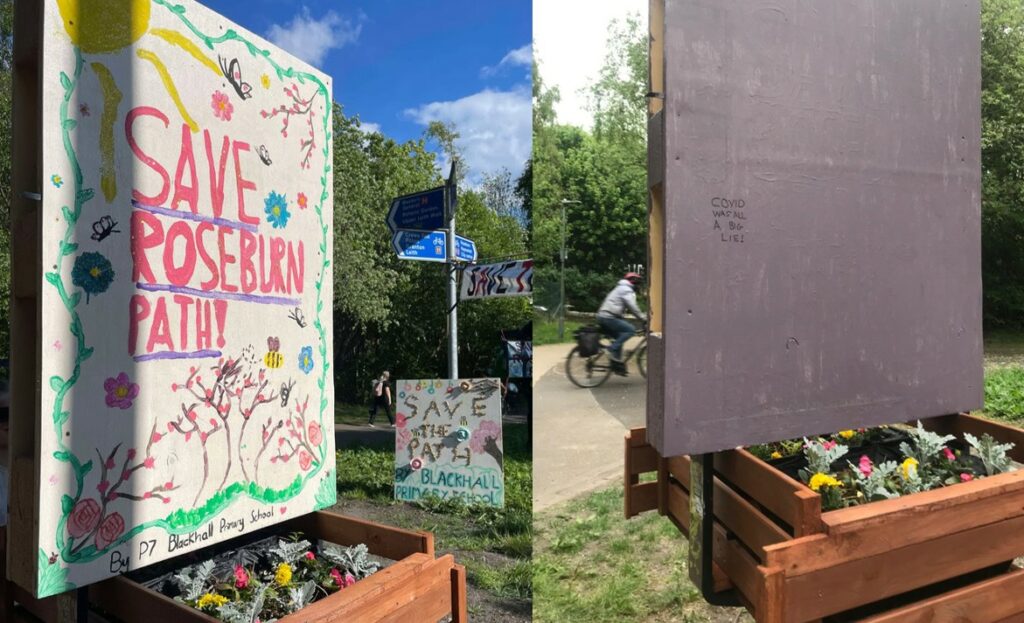
And earlier this month, the ‘Save the Roseburn Path’ group unveiled three signs designed and produced by P7 children at nearby Blackhall Primary School.
The signs, which were created during school lunchtimes, called for the council to “save the path”, while also juxtaposing the corridor’s current green space with what the schoolchildren view as the potential for a grey, litter-filled landscape caused by the tramline.

However, just days after they were first unveiled along the path, Edinburgh City Council called for the signs to be removed “immediately”, arguing that the debate around the future of the Roseburn Path is a “sensitive” one.
The local authority, however, has also claimed that the signs were vandalised before they could be removed, and were painted black to cover the offending graffiti (shortly after they were painted over, graffiti claiming “Covid was all a big lie” was spotted on the vandalised sign), before being returned to the school.
“I am aware that a group of children from a local primary school have created artwork which was displayed along the Roseburn Path,” James Dalgleish, the council’s education, children, and families convener told road.cc.
“Although I welcome pupils taking an interest in issues happening in their community, there are clearly sensitivities around this specific topic and how the opinions of pupils are expressed. The artwork was created outwith the class curriculum and during lunchtimes.”
Dalgleish continued: “Before council officers were able to securely remove the signage, the artwork was sadly vandalised. The signs have now been taken down and returned to the school.
“We understand that the damage to the artwork, which children spent time and effort to create, may cause upset and I am disappointed that this has happened.”

According to one campaigner, Nuala Roger, the schoolchildren have responded to the signs’ removal by “already discussing how they’re going to resolve it and coming up with some brilliant ideas of what message to put up about saving the path”.
“The council are being so shortsighted and not thinking about the next generation,” Roger wrote on the ‘Save the Roseburn Path’ Facebook page.
Meanwhile, Liberal Democrat councillor Sanne Dijkstra-Downie, whose party has been a vocal critic of the Labour-led local authority’s plans to install the tramline along Roseburn Path, described the decision to remove the signs as “so, so disappointing”.
“Really sorry to see this. I’ve met the P7s at Blackhall Primary on multiple occasions and they are some of the most engaged and thoughtful people I’ve ever come across,” she said.
“What message does this send to kids who care about their local environment?”

The vandalism and prompt removal of the schoolkids’ posters isn’t the first time this year that homemade signage opposing the Roseburn Path plans has been targeted by the council.
In March, Edinburgh’s transport convenor Stephen Jenkinson asked council officers to rip down a sign encouraging locals to access the savetheroseburnpath.com site “as soon as possible”, after describing the poster as “ugly”.
Jenkinson claimed the sign did not have planning permission to be installed adjacent to the path, while local cycling group Spokes denied any involvement, despite their logo appearing on it.
> “Travesty” if tram extension plan leads to loss of “much-loved” cycle path, says councillor
Criticising the council’s plans during a meeting last year, a Save the Roseburn Path spokesperson said: “Our objective is clear: to stop the proposed tram extension going down the Roseburn Path. We want to protect the integrity of a key active travel corridor.
“The route is used by Edinburgh residents for walking, running, commuting, cycling, bench sitting, and spending time in nature. It’s a slice of calm in our busy and often stressful lives.
“We want to protect one of Edinburgh’s last remaining urban green spaces. If the City of Edinburgh Council is allowed to build on this space, it opens the door to further expansion in other green spaces, with particular risk to other areas of the path network.”

In March, Jenkinson announced that a consultation will begin on the two proposed tram routes in the middle of August.
The transport officer said he is giving officers and consultants “the space and the time to look at all the options on the table for Granton to BioQuarter” and confirmed there will be a full 12-week consultation “which will then form the basis for a report to be considered by the Transport Committee probably in early 2026”.
He added that he had agreed the timing for the consultation with council officers to avoid school holidays and that he wants it to be as “robust as possible”.


14 thoughts on “Schoolchildren’s ‘save the bike path’ signs vandalised, after council ordered removal of artwork due to “sensitivities” surrounding controversial tram route plans”
“There’s somewhere people go,
“There’s somewhere people go, and enjoy going. People from all walks of life, go there and use it.”
“Is it free to access and use?”
“Yep. Totally”
“Fuck ’em … rip it out. Can’t have people enjoying themselves for *free*”
As someone who’s a pretty
As someone who’s a pretty heavy user of the paths (albeit I am at the north end of this – but it would still seriously stuff up my main route into town / to the most convenient railway station)… a few notes:
The key points here as I see are:
Edinburgh wants to grow (by adding housing on outskirts).
Edinburgh says it wants to provide choices for transport and not just have motor vehicles. They are taking some steps about reducing some traffic in the centre… albeit the “joined up thinking” seems lacking.
Edinburgh has an inheritance of a network former urban railways – pretty much all currently form what amounts to the active travel backbones of the city (and indeed a genuine network – albeit one of “branches” rather than a grid – in the North / Northeast).
Because of that the city has been rather slack about active travel provision (and doesn’t seem to have thought of larger scale “networks” very often).
Like everywhere we know it’s really hard and unpopular to disrupt driving (and the buses…) or remove parking spaces.
The geography of Edinburgh is hilly – and in particular travelling north-south means dealing with notable hills and a sharp river valley.
There is really a single current tram line, which runs east-west to the centre then north out toward the sea (Leith) and back along the short a short way. Amusingly – or maybe not – they still refer to this as the “tram network”.
Oh … and the existing tram in fact largely follows an existing bus route (22), and indeed an existing train route. So while it acts like a tram in the centre (a walking acellerator with relatively short distances between stops, and fast boarding because high capacity to get people on / off) to the West it’s more like “medium rail”. I’m not entirely sure it doesn’t get “stuck in traffic” to some degree either although trams have their own signals and we should be able to prioritise them?
councillor wrote:
…we are very sensitive about being criticised over it— councillor
mdavidford wrote:
Exactly. They are very sensitive … as are quite a few drivers / businesses.
The previous Convenor (Scott Arthur – seen here cycling the proposed route) was explicit that a lot of the justification for choosing this route was to avoid yet more controversy / pissing off the public – which they’d mainly done royally (and with a remarkable degree of bloody-mindedness – we’ve started now so we’ll finish no matter what) with the first tram fiasco and then again with the tram line extension. They’d also had a prolonged fight with a small group very opposed to “space for cycling” around Roseburn / on the CCWEL. Who incidentally probably made things far worse for themselves by delaying matters than if they’d just piped down.
I suspect some were well-connected folk…
Not sure the vandals are sensitive though – they’re quite happy to vandalise the stuff that the council likes also.
This is a fairly common
This is a fairly common situation, whether to take space away from active travel or drivers. The same thing happened in Bristol with their railway path, and fortunately the tram proposal was dropped after fierce opposition. But when you really think about it, the answer is obvious: take the space from motor traffic. Sure, they’ll complain and say that the world will come to an end if you take away so much as an inch of provision for cars, but it won’t.
If they take away active travel provision, they’re sending a clear message that drivers trump pedestrians and cyclists in their hierarchy: I thought most places had progressed enough to see the futility of that approach. I haven’t checked the council’s transport strategy, and I can’t be arsed to do so, but I bet it starts with pedestrians and cyclists and finishes with car drivers.
Grow a pair Edinburgh council and stop being wimps.
I look at it and while I can
I look at it and while I can vaguely see arguments about ‘where else do you put the tram’, a big chunk of the issue is that they could take space away from roads to put a dedicated, full width, properly segregated cycle lane in elsewhere. (even if still a massive compromise vs cycling through a nice green area)
But the minute you propose that you pretty much get ‘what about the cars’ because basically any sensible transport link has a road down it… (canals, rivers (waters of lieth), hills and railway lines (even if viaducts so above)) all control where you can easily put routes (even if you were willing to knock down houses.
That area has a fairly decent start on a network of off road high quality routes, I suspect because it was at one point local railway, so historic routes between destinations AND hooks into the union canal – its cycling infra built along transport routes that were either desire lines OR drove the shape/growth of the city, creating desire lines.
But if you lose the roseburn path, significant chunks of what they have built so far become useless (oh great, I can cycle on dedicated infra to the local corner shop; But WTF would I cycle rather than walking given how close it is, vs being able to cycle a couple of miles further into central edinburgh, or to the local beach etc etc…).
The paths are kind of
The paths are kind of “inadvertent infra” – people didn’t especially desire to travel those routes before (or at least – they would be doing so longer-diatance on the train, plus I think the branch to Granton was mainly for industrial purposes – although I didn’t read the local history in detail yet).
But … turns out that longer-distances are what the cyclists who are left are happier doing. And a gentle gradient in a hilly city is a boon. And almost everyone likes green spaces where you can’t hear or see motor vehicles. (Just… not at night, for the majority!)
Trams are great – but should run on the streets. So absolutely where the cars and buses go! Some Edinburgh councillors get it but the problem is we’re still getting stuck with the idea that the cars have to be there, we can’t risk alienating people by actively making it much less convenient to drive etc.
It’s also the case that for “mass cycling” the cyclists want and need to be on the streets too – mostly because it’s just about people accessing facilities (as they would by walking or having just for of the tram). And lots of the main routes still have lots of car and bus traffic. So we will often need separate cycling space. (Never mind that the council also completely failed on the safety of cyclists around trams before – in fact just stuck their fingers in their ears – so we’ve had a cyclist dying and they’re paying lots of injury compensation).
Id love it if we could keep these spaces for active travel (obviously – regularly using all the North Edinburgh ones for commuting, to access amenities, as my recreation and exercise…) That may not ultimately be the best use for all of them if we do want to reduce car dependency. What concerns me is the prospect of throwing away something which could be the spine – the “cycling arterials” – around which a very good (for the UK) active travel network grows. Because to adequately replace it (in terms of “attractiveness”) the council will have to work a LOT harder to deliver significantly higher quality infra and fight *far* more noisy battles than they have up ’till now.
I’m not convinced they are sufficiently convinced that cycling is that important. (And there are certainly a few antis – who apparently would rather we didn’t, or at least that it goes to the back of the queue.) Or that it needs prioritising if they want more than the usual few % swapping car journeys for riding (the usual hopes that “encouraging cycling” will do it). And ultimately a single extra tram line (or even the originally planned network) isn’t going to replace those…
qwerty360 wrote:
Don’t know if you’ve seen this one – on what trams can do and what they do best?
Coming back to this – it’s another case of “we need *multiple* things which we replaced with ‘one tool for all’ driving”.
– For servicing new development (like in NW Edinburgh) we need local *rail* (like what was in this space before! ) for quick transit across longer distances. (
Trams can and do function as mini trains in places but having lots of stops works *against* “commute from suburbs / fast connection to the airport”.
– To replace short trips in the centres we need the “walking accelerator” – a tram network. Ultimately this should be *replacing* lots of buses. Large start-up costs but in fact trams are cheaper (to run), faster, safer (especially for pedestrians and also cyclists) … well, that is if you don’t let Edinburgh council near them…
– support for fast and efficient local private transport of self and goods. That is cycling and wheeling on traffic volumes and speed reduced streets or on separate infra where it’s faster / busier. Cycling can also expand the catchment area of public transport (especially rail – just copy the Dutch with excellent secure cycling garages at stations – maybe even with rental bikes? )
It’s not easy of course, and every UK city can list dozens of barriers and local issues.
But while Edinburgh *is* hilly and does have “but but narrow historic streets” a great deal of the place has a large distance between building frontages. We should be rethinking what this space is for. And we should be doing this at a network level. Not all streets need to permit two-way motor traffic!
This feels easily fixable.
This feels easily fixable. Why are they not just building a sufficient new path next to it? Then everyone wins. Probably not at a great deal of cost either.
Due to cuttings and
Due to cuttings and embankments this would not be cheap. Apparently the “historic bridges” are chokepoints which mean there isn’t sufficient room. I have my doubts (not that it wouldn’t be expensive, but I suspect the bigger factor here is “we’ll get it in the neck from drivers if we have to take a bridge out of commission for months” (which it would likely take).
Plus at the end of that you’d still have replaced a walk through a tranquil green space with one where you’re squeezed between fences next to a railway track, so it’s still a genuine loss.
It’s the “it is fixable – if we could change everything at once”. Ideally trams should mostly run on streets (that’s what they’re best at) and if we are taking back this space it should be for trains. But we already experienced howls of protest from drivers (well – everyone) installing a single truncated tram line. (TBF that was mostly justified – Edinburgh had a compete mare with this and that wasn’t helped by the bunker mentality of the council and tram co when correctly challenged on their many avoidable mistakes).
Public transport is also reliant on buses ATM and we don’t have enough tram routes to replace those – so both may get in each other’s way. And if we have buses we have taxis, and then “why not deliveries, and
private cars”…
We don’t already have fast trains running in from more of the outskirts (at least in the north – that’s what these paths were) so people drive. We don’t have a grid of good cycle routes to be attractive enough that many people use those for efficient local private transport…
Hi boxrick,
Hi boxrick,
The installation of a tramway would involve the removal of about 3,500 trees. Right now it’s a beautiful woooded path – full of life. (I encourage you to check it out : ) ). All that would be destroyed under these plans.
Best wishes,
Joe
This feels easily fixable.
This feels easily fixable. Why are they not just building a sufficient new path next to it? Then everyone wins. Probably not at a great deal of cost either.
I can’t understand why
I can’t understand why everyone is getting excited. There is no way the necessary funding of a few hundred million will be available in the current economic climate. Although it won’t stop the council spending tens of millions on consultations.
Not transport related, but even if they could find the money, as Edinburgh has rightly declared a housing emergency helping solve that would be better use of the funds.
I’m not sure.
I’m not sure.
It’s all choices… With what they are currently doing with house building (West Craigs etc.) it seens little different to a “predict and provide” approach to “congestion emergency” – and we know “build more roads, just get more traffic (and a bigger maintenance bill)”.
I surely don’t know what I don’t know but the approach to said “housing emergency” in Edinburgh appears to be relying on “trickle down”. At least, they don’t seem to be building a bunch of new council housing (though a few of the new units are apparently “social housing”) to replace all the bad accommodation. Or the old stock the council knocked down over the last decade (TBF some of which was pretty ropey). That land was developed – AFAICS the deal was the usual “a few social houses and a one-off payment” – so effectively converting capital to temporary income while handing someone a good development deal…
So … not sure their plan is a “good deal” in the medium / long term.
On the trams – a tram network would be great. In most other European places that have this city places are nicer (imagine Princes Street without the buses!). Possibly a bonus for tourism – although perhaps that’s a given? It likely saves a lot of cash when compared to relying on the current mix with buses and plenty private motoring (though the council already incurred vast costs with the first line fiasco…).
But we clearly couldn’t
manage a piss up in a brewerymanage to get a network in one go. So the council are trying to do it piecemeal and sticking in trams where it’s cheapest / causes least objection (hence along the Roseburn path). Of course they say they’ll find “alternatives” for cycling … but it’s not clear what they’d be. And if they did that would immediately bring about a fight they wanted to avoid again (the better and more direct the cycle infra the worse the outrage as other interests have to compromise).