

We’ve been having a little play around in the road.cc office with the latest version of Strava Global Heatmap, launched yesterday, and we’ve found some very arresting images, plus others that are just plain weird.
> Strava launches new Global Heatmap based on 1 billion activities
So, here’s a selection of some of the more ‘out there’ places we’ve found on our virtual trip around the globe where people have apparently been cycling and have uploaded their rides to the social network.
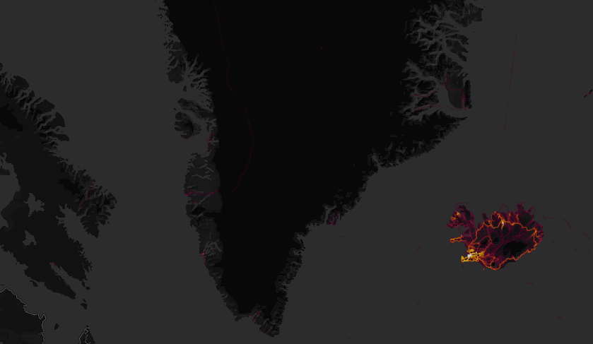
We say “apparently” because unless someone’s sticking a GPS on a pedalo, they’d have trouble cycling off the coast of St Helena, while we suspect a skidoo may be involved in the image from Greenland below.
We’ll start off with one of the more spectacular images – the site of the Burning Man Festival in the Black Rock Desert in Nevada. One of the festival’s founding principles is “leave no trace” – clearly interpreted as not applying to Strava uploads from a GPS by many of those who use two wheels to get around the sprawling site each summer.
Next up, the two Koreas. South Korea is ablaze with activity, shining as brightly as Japan, in the bottom right-hand corner – but across the world’s most heavily fortified border, it’s almost pitch black.
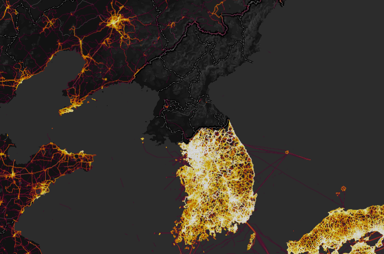
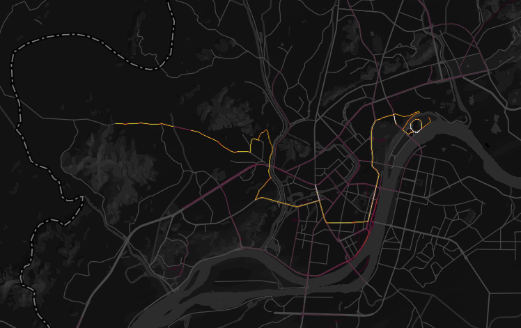
Almost, because zoom in on the capital Pyongyang, and it’s clear that some people are using Strava in the city. There’s even evidence of a bike ride all the way to the border with South Korea – although whether the cyclist concerned ever made it across is anyone’s guess.
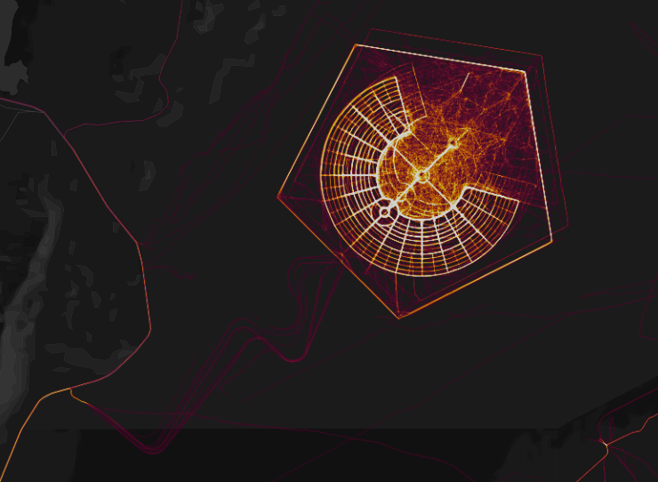
This one is weird. Jarvis Island, administered by the United States, lies pretty much smack bang in the middle of the Pacific Ocean – yet it is uninhabited.

The only visitors are the US Coastguard and US Fish and Wildlife Service, who go there periodically, plus any scientists or academics able to get a permit to visit.
Yet there, on the Strava Global Heatmap, is an image shaped like a ghost. It’s got us stumped.
Over in the Atlantic Ocean, St Helena, has what in relative terms is a burgeoning population of around 4,500 people. One of the most remote islands on the planet, as this forum post shows, people do cycle there – and some upload the proof to Strava.
Here’s another strange one. A well-travelled, straight route slap bang in the middle of Greenland. While it appears to be in the rough area of the North East Greenland National Park, we can’t see any settlements that might be linked on any maps we’ve looked at.

Zooming out gives an idea of its rough location – it’s towards the top of this image, in the middle.
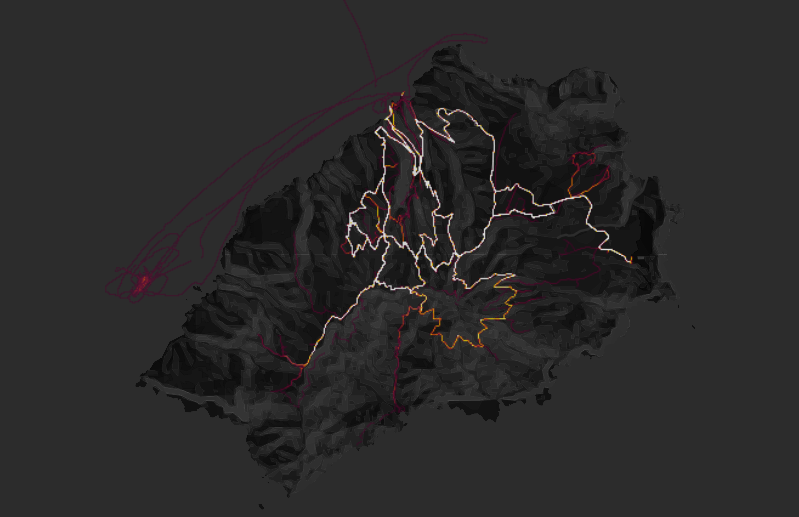
Finally, we thought we’d better bung something recognisably cycling-related – so here’s the unmistakeable switchbacks of Alpe d’Huez.
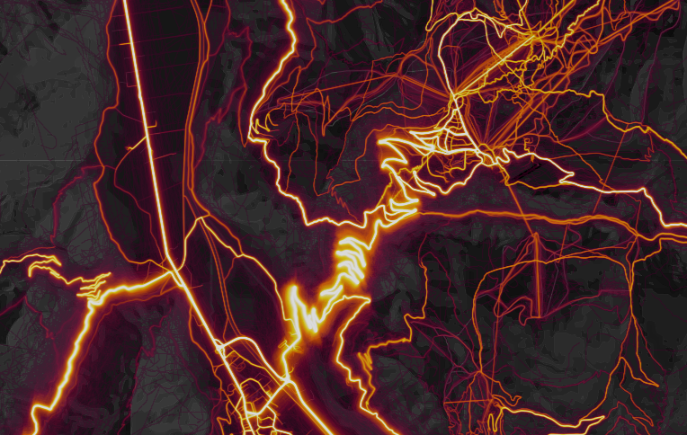
It’s easy to spot the route to the summit favoured by the Tour de France and amateur cyclists looking to conquer the same ascent the pros take.
Have you spotted anything unusual on Strava Global Heatmap? Let us know in the comments below.


14 thoughts on “Six arresting – and strange – images from Strava Global Heatmap”
The Jarvis Island one is
The Jarvis Island one is simple. It’s the original location for Zwift, way back in the day before Watopia existed
Most of the usage in
Most of the usage in Pyongyang will be the marathon. You can pretty much make out the course and the stadium.
gbadman wrote:
These are supposedly filtered by rides.
Now I can see those dirty commie bastards stealing KOMs by logging rides as runs all over the planet, but recording runs as rides? What would Young-un have to say about that..?
Loving all the people
Loving all the people ‘cycling’ across the channel!
Norilsk in Russia was what
Norilsk in Russia was what peaked my interest… It is the world’s northernmost city with more than 100,000 inhabitants, inside the artic circle, and has what looks like a velodrome if you zoom in!
How about a bit of dune
How about a bit of dune surfing in the Algodones dunes in california? pretty.
Could the Strava trace over
Could the Strava trace over Greenland have happened because someone accidentally turned on their system briefly while sitting in aircraft flying overland, but under the satellite? That’d explain why it’s nearly a straight line too.
OldRidgeback wrote:
I think the line’s too bright to be just a single journey. You can see very faint lines in lots of places where people wouldn’t normally cycle (or are doing some other activity and haven’t set their GPS to the right sport). The line over Greenland is quite bright which suggests multiple tracks.
kamoshika wrote:
It’s most likely a landing strip at a research station and someone is either getting some exercise going up and down on a fat bike (it’s probably the only bit of solid flat ground for many miles) or they are recording while they are out clearing the strip in a Snowcat.
OldRidgeback wrote:
A quick look on Segment Explorer shows there are three segments there:
https://www.strava.com/segments/15129463
https://www.strava.com/segments/15129485
https://www.strava.com/segments/15129334
Unsurprisingly, the same person (https://www.strava.com/athletes/14234684) has the KOM on all of them, and there’s only one other person on the leaderboards.
kamoshika wrote:
Good spot. You can see from his photos it is indeed a landing strip (for aircraft on skis not wheels)
It’s this place
https://en.wikipedia.org/wiki/Summit_Camp
looks a bit on the cold side
Another thing to look at
Another thing to look at would be US interstates where bicycles, runners etc. are not allowed.
https://labs.strava.com
https://labs.strava.com/heatmap/#11.82/-0.15796/53.57853/hot/ride
There is this image that was
There is this image that was created purposely as art, there are few of these around: https://i.pinimg.com/736x/7d/e4/07/7de407c8c1d9b12d54ca05a196b29f11–new-forest-bicycling.jpg
And this one: https://pbs.twimg.com/media/B-40RWuUsAAuDRc.jpg
And: http://ichef.bbci.co.uk/news/976/cpsprodpb/18046/production/_88347389_mermaid.jpg
There are more of this sort of thing as well. The only thing I can explain how this sort of art could be made is someone drawing the outline on a paper map first then ride it. There probably is some other way I’m not aware of.