

- News
- Reviews
- Bikes
- Accessories
- Accessories - misc
- Computer mounts
- Bags
- Bar ends
- Bike bags & cases
- Bottle cages
- Bottles
- Cameras
- Car racks
- Child seats
- Computers
- Glasses
- GPS units
- Helmets
- Lights - front
- Lights - rear
- Lights - sets
- Locks
- Mirrors
- Mudguards
- Racks
- Pumps & CO2 inflators
- Puncture kits
- Reflectives
- Smart watches
- Stands and racks
- Trailers
- Clothing
- Components
- Bar tape & grips
- Bottom brackets
- Brake & gear cables
- Brake & STI levers
- Brake pads & spares
- Brakes
- Cassettes & freewheels
- Chains
- Chainsets & chainrings
- Derailleurs - front
- Derailleurs - rear
- Forks
- Gear levers & shifters
- Groupsets
- Handlebars & extensions
- Headsets
- Hubs
- Inner tubes
- Pedals
- Quick releases & skewers
- Saddles
- Seatposts
- Stems
- Wheels
- Tyres
- Health, fitness and nutrition
- Tools and workshop
- Miscellaneous
- Cross country mountain bikes
- Tubeless valves
- Buyers Guides
- Features
- Forum
- Recommends
- Podcast
forum
Maps for Garmin Edge 800
Hi,
I have an Edge 500 and am thinking about upgrading to the 800. I was going to put it off until holiday-time (when I'll take my bike and doubtless be riding on unfamiliar roads). However I'm re-evaluating that after I want on a familiar ride last week and missed a turn 'cos I was daydreaming!
Anyway I'm a bit confused about the available maps though, was wondering if anyone could help? Not least since the "map" side of things appears to be responsible for a fair part of the total expense of the system.
- the UK Ordnance Survey option - fortunately this option is clear to me, though I would probably class this as a nice-to-have rather than a necessity
- the "City Navigator" maps. These are the most confusing. What type of map should I expect here? Something akin to the one I see on my car satnav? And bottom line, are they any good?
- the Topo maps. Are these just the non-UK equivalents of the Ordnance Survey maps? So if I bought TOPO France, for example, I'd see IGN maps?
Aside from the differences in the maps, presumably all can be used to calculate a route somewhere?
Putting money to one side for a moment, my preference would be to have the OS maps. However when I think about holidays, we regularly go to France, last year we went to Luxembourg and I ended up cycling in Germany too. So my ideal would be not only having the UK OS map, but having the (topo?) maps for a couple of other countries also. Bringing cost into it, everything then becomes very expensive - several hundreds. Contrast this to the City Navigator, with which I can get the whole of Europe for £75.
One other question, not so much the maps but on the memory slot. I know it is micro SD but haven't been able to find what the maximum size of the card can be. For example I can fit a 32GB card into my phone, but many devices will baulk at a card that size. I believe when you buy the Garmin maps on the cards, they come on 4GB cards. This might be enough for one map but if I did end up buying two or three maps... just wondered what kind of card capacities are people using?
Also, be useful just like to hear peoples' general views. Thanks.
If you're new please join in and if you have questions pop them below and the forum regulars will answer as best we can.
Latest Forum Topics
Latest Comments
- Simmo72 2 hours 56 min ago
TNT can sit on my seatpost and swivel. Not giving a penny to the vile bean counters.
- Johny 3 hours 4 min ago
Hey Surrey rider do you even know where Hebdon Bridge is? Have you ever been there? Yeah thought not. Soft southern Jessie , we welcome your opinion.
- David9694 4 hours 35 min ago
Dawlish driver suffered seizure before smashing into wall...
- C3a 4 hours 46 min ago
I agree. Off to sign.
- themuffle 4 hours 59 min ago
With both Hunt and Scribe, I really think you'd be mad to get wheels from anybody else.
- Sriracha 5 hours 39 min ago
Weight is a problem when it costs you in energy on the uphill which is lost on the downhill, or lost in braking. But if that energy can be...
- ktache 6 hours 29 min ago
And because they are so likely to flip and are heavier they have to have stronger and wider A pillars which reduces visibility.
- MatzeLoCal 6 hours 35 min ago
What amazes me most is how small the north american market is....
- bikes 6 hours 36 min ago
"perhaps unavoidable", as gently easing off on the accelerator pedal for 2 seconds would obviously be out of the question.
Add new comment
3 comments
I recently wrote a blog post about various mapping options on the garmin edge 800, with some video showing a comparison between OS discoverer maps and free OSM maps such as velomap and talkytoaster.
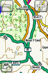
hope it's of some use - http://www.scarletfire.co.uk/2012/02/osm-maps/
Thanks, that's great information. The DC Rainmaker review also is gold dust, far more informative than anything I've found on the Garmin site.
Think I agree with your conclusions. As and when I get the 800 the euro city navigator maps is a must, the os map seems to be a nice-to-have. (So basically will get it if I can find it cheap enough.) The screenshots in rainmaker's review have allayed my fears somewhat about the quality of the city navigator maps - I think my biggest fear was if they turned out to be rubbish and I ended up being almost obliged to buy the os/topo maps.
Interesting also that rainmaker used a 16gb micro sd card, which should be large enough for several maps if needs be. I take your point about licensing between device/card. Both the City maps and the OS map are available as downloads on the Garmin site so presumably it must be possible to register them to the device. But of course buying from the Garmin site may not be the cheapest option...
Incidentally I'm coming at this from a purely road perspective, any off-road function doesn't figure in my list of priorities.
Thanks once again.
i have the 800 with the euro city maps (came with it) and UK discoverer (ordenance survey). I use the former when road cycling in UK and europe (mostly just spain) and the latter for general use. I also bought the birdseye sat image licence thinking it would mean not needing discoverer (was wrong, birdseye needs loading via garmin software and is an absolute PITA, also sat imagery only really works on glossy mobile screens)
the licence is either for device or for card, most now foir card - so putting the maps all on one card is only an option for former, but tbh swapping cards is no biggie.
i will say however, that i have done 125km road rides in foreign countries and 90km off-road rides using the breadcrumb map on a garmin 310xt and not got lost (i used a phone with satellite images or trial an error when "off course")-it works!
finally, 6 of us did the transcambrian off-road, one with topo, me with discoverer and another with just waypoints on standard map and sometimes we needed to use human powers of deduction to work out between the three which was the way forward!
what was clear is that discoverer is better than topo, at least in UK. the only other country i have seen topo maps for was spain, but they were no where near as good as the UK ones, i would not buy topo for each country just for holidays tbh.
in sum,
1) i would not upgrade from 500 just for mapping on road, unless you plan on "exploring". overall I would say that its harder to follow the course on a map than a breadcrumb while cycling (i have gone into menu and changed colour so the route stands out better, but need to slow down more than with breadcrumb map on B&W screen to read it). On the other hand it does save time back on situations where you are not sure of way forward, as a colour map clearly lets you see the options. for off road an edge 800 with OS maps it is better.
2) if you are a road cyclist and want europe, city maps should be better. if you do both or just UK, discoverer is better would be my opinion. the review by DC rainmaker (google: dc rainmaker) shows you the difference in quality of base map vs city. However, what I have not tried is breadcrumb on base map...but i honestly think the analogue breadcrumb on the 500 and a mobile for back up will get you where you are going better than a full colour crap base map and the same breadcrumb trail but just more difficult to read, at least on the road.
so get euro maps + 800 or stay with 500 would be my advice