


In 2021, Beeline launched the Velo 2, a second generation device founded on the young British company’s unique approach to cycle navigation – namely, that your navigation device shouldn’t distract you from the ride itself. Unlike other bike computer and navigation brands, who often provide almost too much information in less-than-intuitive ways, Beeline’s goal was to put intuitiveness front and centre.
To that end, Beeline’s original Velo ‘smart compass’ navigation was beautiful in its simplicity: a digital arrow simply pointed you towards you destination. But with the Velo 2 – thanks to a continual programme of software improvements – Beeline has been able to do a lot more without losing any of that initial visual simplicity.
“The Velo 2 still has the single arrow function as an option for that original Beeline magic. However, it also now uses a map-based interface, which is a much more versatile tool for riders’ different needs,” Beeline founder Mark Jenner says.
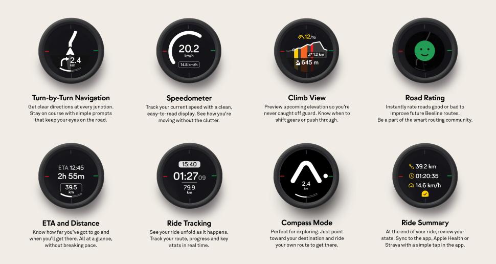
“We’ve done lots of work making sure the navigation interface – the screen you use when you are riding – is able to deal with specific routes and different terrains. We’ve come up with our own ways of dealing with things like roundabouts and other features you’ll come across en route. We’ve really focused on making it intuitive and easy to see at a glance.
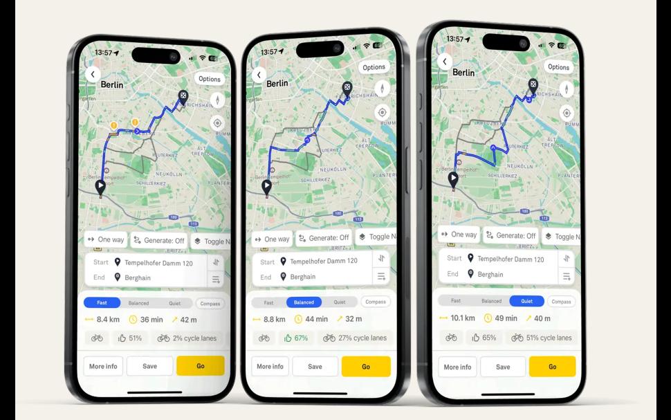
“We’ve also done a lot of work on the route planning side of things. Rather than just relying on the smart compass, you can plan your routes in the Beeline app, which is very easy. You can create loops if you’d like – the app will do that for you. You can choose your own route preferences between fast, balanced or quiet. And the quiet and balanced routing is based on the feedback we get from users who have ridden those different routes.”
Space-age feedback
That notion of community feedback has been another area where Beeline is just a little bit different to typical bike navigation brands. The Velo 2 allows users to give either a thumbs up or a thumbs down to the route they are currently using. That data is then collected and collated in Beeline’s database.
“This data not only influences the specific place where that feedback was given but the system will also look for similar roads and it will apply the feedback to them as well. That routing algorithm is one of our big projects and we actually got some grant funding from the European Space Agency to support us in developing this way of doing routing,” Mark says.
Hills are another area where Beeline has made great strides. With most of us cyclists not being of the elite level ‘laugh in the face of climbs’ variety, it became obvious that warnings and information about climbs was greatly valued.
“As a screen on the device, we’ve included an elevation chart, where you can track your progress through the ride, showing as you go over hills. All hills are colour coded depending on how hard they are,” Mark says.
“Even when you’re just navigating normally, when you hit a hill, it will go into a hill mode that shows you how far up that particular hill you are, and how far you are from the top. So that feeling of reaching what you think is the summit of the hill, only to find there’s more climbing to go, shouldn’t happen anymore. You can have some foresight to get you up the hill without running out of steam.”
Continual developments
With a total Beeline team of 25, the improvements are continuous. Most recently, Beeline added integration with Komoot (it was already able to integrate with Strava) so users can transfer their routes. You can also now start tracking a ride from the device, without needing to access the phone app first. Mark says route following will be possible in a similar way soon.
The Velo 2 device itself has also had a slight upgrade, with a silicone case wrapper making it more robust, along with improved the screen brightness.
The product, and the company, has come a long way since a late arrival acted as the genesis for a business idea.
“Myself and Beeline’s other founder, Tom Putnam, used to live in London and we both thought it would be quite cool to make something, a little gadget, that could just point you in the direction of where you wanted to get to. We didn’t want it to do any complicated routing, just literally give you a compass arrow for direction and say how far away your destination was,” Beeline’s Mark Jenner says.
“That was our initial product idea and, funnily enough, when we decided to meet up to chat about what we wanted to do next with our lives, I got lost on the way. So that rather sealed the deal.”
Kickstarting into action
The concept was simple.
“We had this idea of a smart compass, so we decided to explore it a bit more,” Mark says.
“We found someone who made us a very basic app where you could write your destination and it would give you a compass arrow aiming towards it. We put this on our bikes to see if it worked and, immediately, it was great. But it was also really different to using a traditional satnav. The device or app might be pointing towards your goal, but you as the rider still decided which way to go.”
With proof of concept successful, and ambitions to take this further, the next milestone was a Kickstarter campaign to see if the idea had traction among a wider cycling community. Three thousand Kickstarter backers suggested it did.
“That was when the real hard work started. We had the hardware to design, we also had an app to build,” Mark says.
In the eight years since the initial product was released, while the conceptual essence remains the same, there has been a multitude of significant software updates and improvements.
The cycling public has certainly seen the attraction of Beeline’s approach. Beeline products are now sold in more than 70 countries around the world, including Japan, Germany, Australia and the USA. Even an unsuccessful appearance for Mark and Tom on TV show Dragons’ Den hasn’t stopped more than five million rides being taken using Beeline technology, and more than 150 million miles being guided by it.
And it’s not stopping there, with one more game-changing development in the offing.
“One thing that we are exploring at the moment – and we are actually already in development with one partner – is whether we can make our navigation available built-in to a bike,” Mark says.
“If you think about our aim, which is to make navigation as fuss-free as possible, if you had the device built-into the bike, that would be the ultimate fuss-free experience.”
To find out more about Beeline, visit beeline.co


7 thoughts on “How Beeline is doing bike navigation differently with fuss-free, intuitive simplicity”
I like my Beeline, and used
I like my Beeline, and used it for most of my LEJoG last year. I’ll be using it all next week for RAGBRAI.
My Velo2 certainly doesn’t have a silicone case like the one pictured. Or are they saying there’s a newer version, but it’s still the Velo2?
I have three main complaints worth mentioning.
The first is that when I pull in a GPX file created outside of Beeline, and choose turn-by-turn, it will over-rule my route if it thinks a road doesn’t go through, and try to route me around it. I just want it to follow the route, not second guess it. The breadcrumb option is not a real option to work around this.
The second is that sometimes, especially if a road turns but a minor road branches off in roughly the direction the road was going, it erroneously thinks that it’s not really a turn and doesn’t notify me. I missed a couple of turns and had to backtrack on LEJoG because of that. The only way to know you went off course is if you have a screen up with navigation info on it, and happen to notice that the distance to the next turn has started increasing.
The third is the speed it uses to predict time of arrival. It seems to be using 15 km/h (9.3 MPH.) When I go on a longish ride, that makes the arrival way, way off. I recently rode 50 miles, and I left at 9 AM with a predicted arrival time of 2:30 PM. I arrived at 12:35. The value displayed is essentially useless until you have about five miles to go.
They did recently do a firmware update to fix one of my previous complaints, which was that although you can end a ride from the unit, you could only start a ride from the phone app. I’m glad to see that is fixed.
Never used it on a long route
Never used it on a long route like yours, I mainly use it cycling around London, but I do like it. The main advantage being how frugal it is on your phones battery and (especially in London), you feel safer not having a big phone on your handlebars). If you don’t care about power, heart rate, cadence etc. and just want a route planner, it’s a good option.
The Routing has improved since I got it but it still makes some odd decisions (It never wants to route me through Greenwich park for example, which is always a quieter easier route for me, rather than the neighbouring busy steeper roads) , but at least if I know a better route it very quickly adjusts and re-routes.
I really like how it shows ascents now too, it’s a sign theat they are continually developing it and do respond to feedback. I echo what you say about the timing of routes. I guess they are being conservative about how fast people pedal, but it would be good if it could adjust for your speed as you progress, better. I always just take this into account when figuring routes now anyway.
a1white wrote:
Ooh, I hadn’t noticed that. I actually haven’t used it since I allowed it to update last week.
9 MPH is IMO beyond conservative. Google Maps at least does 10-12 MPH (they seem to account for elevation) and I can generally beat its estimate.
Over 25 miles, I’d usually average around 15 MPH, which works out to 1:40. If Google uses 11 MPH, it will say about 2:16, so a little over half an hour overestimate. Not terrible. At 9 MPH the estimate is 2:45, more than a whole extra hour!
Is it because they’re London based, and 9 MPH is a reasonable estimate in traffic?
andystow wrote:
They sell the Velo 2 Protection Pack as a seperate item, I don’t know if the hardware itself has changed (brighter screen?).
I find the Velo 2 generally works very well, although I tend to just stick a few waypoints in and let it do the routing. Much prefer it to mounting a phone on the handlebars.
I’m happy to report that the
I’m happy to report that the Beeline did great on RAGBRAI, once I worked out the correct order of operations to download each day’s .GPX files from RideWithGPS, which is not an app I normally use.
Do I understand correctly
Do I understand correctly that it needs your phone as a GPS unit?
No, it operates just fine
No, it operates just fine even if you turn your phone off, once you have the route in there and get started.
I think it does use the phone if you go off course and ask it to reroute, though.
If you have the Beeline app open, it does seem to use both GPS units in some way. Last week on RAGBRAI, I left the Beeline on my bike whilst walking around with my phone to get food etc. I figured the Beeline would auto pause as it was on the bike and not moving, but my phone’s location got tracked instead. This didn’t happen if I remembered to manually pause it on the device or app.