
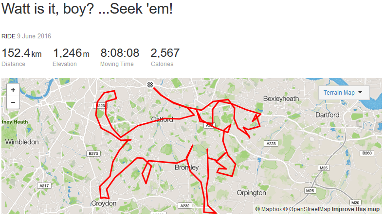
A cyclist has used Strava to sketch out a giant dog during a 152km bike ride in South London.
Marc O’Shea’s ride, which he carried out yesterday, involved more than eight hours in the saddle.
It spanned an area from Brixton in the west to Bexley in the east, and New Cross Gate in the north to Keston in the south.
He didn’t stick to quiet roads, either, with the route including the South Circular, the A2 and the A20.
One of the commenters on Strava has suggested an even bigger challenge – sketching out the person walking the canine.
Here’s his creation.


20 thoughts on “Strava art: Cyclist draws giant dog on Catford in 150km South London ride”
Cool interesting he went
Cool interesting he went through Catford!
Kudos
Kudos 🙂
Gypsy Hill not geeting the
Gypsy Hill not geeting the best end of things
Niiice!
Niiice!
I can see he paws’d at
Very good!
Wonder how he planned this.
Keith Lard?
Keith Lard?
Beckenham is the dog’s
Beckenham is the dog’s bollocks. Oh sorry, my mistake, that’s a leg.
Fake gay photoshop. Unless
Fake gay photoshop. Unless his bike floats on water, and can ride through buildings.
Judge dreadful wrote:
If you turn the Garmin off, ride to the next point and then turn it back on, it’ll just draw a straight line between the point it was stopped and the point it was restarted.
Judge dreadful wrote:
I wasn’t aware that computer programs had a sexuality. How can an image editing program be gay? Does it have to be attracted to other image editing programs? Do photoshop and gimp get it on together once there on a hard drive? If it’s fake gay does that actually mean it’s not really gay and it prefers word processing programs?
Screen grab is the rough
Screen grab is the rough preview you sometimes get. Real thing is much better – just click the link.
Now he just needs to turn the
Now he just needs to turn the whole thing into a segment.
Does look a bit sus. If you
Does look a bit sus. If you zoom into the map on Strava you’ll see that barely any of the route corresponds to any roads or paths at all. Maybe he was piloting a microlite?
guyrwood wrote:
Strava often has me in the sea when I am the coast road here, so not to sus at all.
Two of the off road stretches
Two of the off road stretches are not sus, to my knowledge. Clever moves anyway.
It’s pretty cool
It’s pretty cool
My Strava feed is NSFW, it
My Strava feed is NSFW, it seems to have reached time to cock.
https://www.strava.com/activities/587456650
Just click on the guys name
Just click on the guys name and you’ll see the actual ride, why all the criticism? its just a bit of fun!
If you don’t log in to Strava
If you don’t log in to Strava then you don’t get the full-screen detailed version.
To the doubters, while most
To the doubters, while most road riders keep their computers recording for the whole ride and their whole ride will be shown exclusively on roads. If you carefully start/stop the Garmin, the net result on a map will show the lines corresponding to the on/off points. If a road is straight and the Garmin is started momentarily and then stopped within 2 seconds at its next turn/curve in the road, the result on a map will show a straight line along that road (and also record any difference in elevation). If the Garmin isn’t started again until after the turn/curve, then the resulting lines on a map won’t correspond to a street map.
So for example,
1) the Garmin is start/ stop at the start, then you go exactly one mile on a straight road,
2) then make a perpendicular 90 degree turn on another straight road and go for exactly one more mile,
3) So another Garmin start/stop off at the end of that second road, therefore 2 miles completed
The result on a map will be an offset 45 degree vector line ( 45 degrees with respect to starting point) that originates at starting point and goes directly to the 2nd on/off point at the end of the second road. So the vector line doesn’t follow geography or streets on a map.