

- News
- Reviews
- Bikes
- Accessories
- Accessories - misc
- Computer mounts
- Bags
- Bar ends
- Bike bags & cases
- Bottle cages
- Bottles
- Cameras
- Car racks
- Child seats
- Computers
- Glasses
- GPS units
- Helmets
- Lights - front
- Lights - rear
- Lights - sets
- Locks
- Mirrors
- Mudguards
- Racks
- Pumps & CO2 inflators
- Puncture kits
- Reflectives
- Smart watches
- Stands and racks
- Trailers
- Clothing
- Components
- Bar tape & grips
- Bottom brackets
- Brake & gear cables
- Brake & STI levers
- Brake pads & spares
- Brakes
- Cassettes & freewheels
- Chains
- Chainsets & chainrings
- Derailleurs - front
- Derailleurs - rear
- Forks
- Gear levers & shifters
- Groupsets
- Handlebars & extensions
- Headsets
- Hubs
- Inner tubes
- Pedals
- Quick releases & skewers
- Saddles
- Seatposts
- Stems
- Wheels
- Tyres
- Health, fitness and nutrition
- Tools and workshop
- Miscellaneous
- Buyers Guides
- Features
- Forum
- Recommends
- Podcast


£180.00
VERDICT:
Huge battery life and usable routing make the Mega XL a very good choice if you're going long
Weight:
81g
Contact:
At road.cc every product is thoroughly tested for as long as it takes to get a proper insight into how well it works. Our reviewers are experienced cyclists that we trust to be objective. While we strive to ensure that opinions expressed are backed up by facts, reviews are by their nature an informed opinion, not a definitive verdict. We don't intentionally try to break anything (except locks) but we do try to look for weak points in any design. The overall score is not just an average of the other scores: it reflects both a product's function and value – with value determined by how a product compares with items of similar spec, quality, and price.
What the road.cc scores meanGood scores are more common than bad, because fortunately good products are more common than bad.
- Exceptional
- Excellent
- Very Good
- Good
- Quite good
- Average
- Not so good
- Poor
- Bad
- Appalling
The Lezyne Mega XL might be just the ticket for you if you're into long rides and you want to follow a route from your handlebar. You'll not find a GPS computer with mapping that gives you a better run-time than this one, and overall the routing works pretty well. There are some usability issues along the way, and it's not the most attractive unit out there, but it's a well-specced computer for audax and distance riding.
- Pros: Massive battery life, offline mapping and routing, easy to configure from the app
- Cons: Slow activity uploads, desktop route creation is poor, not as intuitive as some competitors
> Find your nearest dealer here
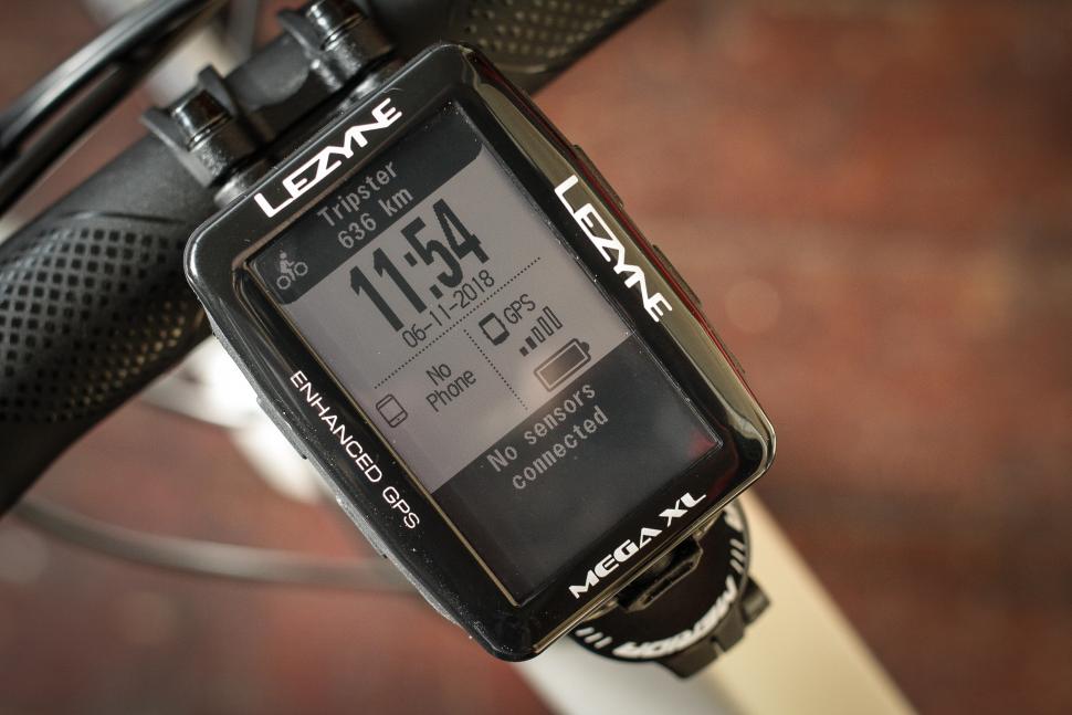
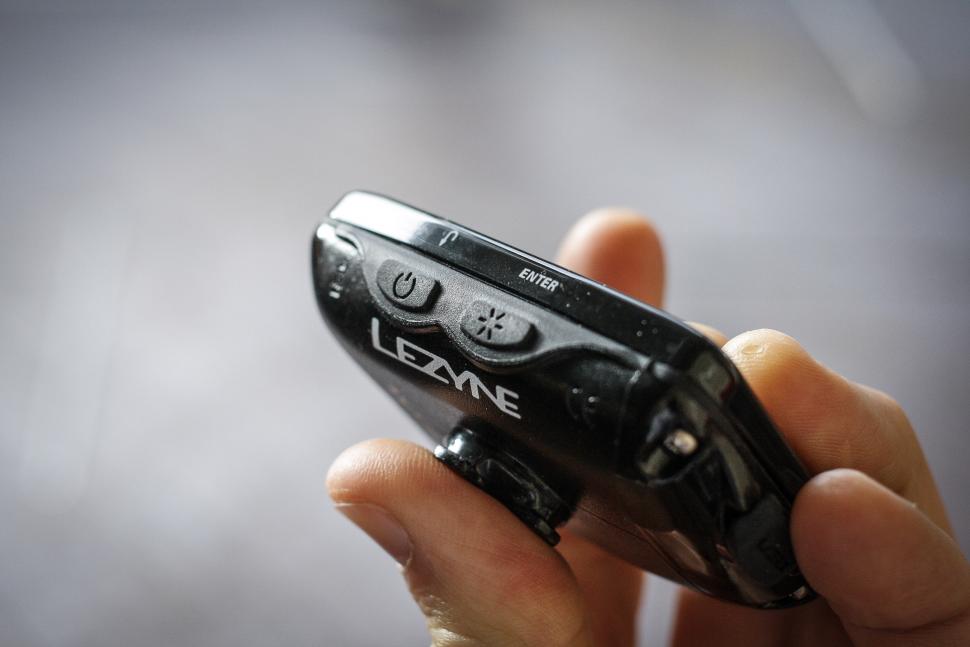
The unit: well made, solid mount
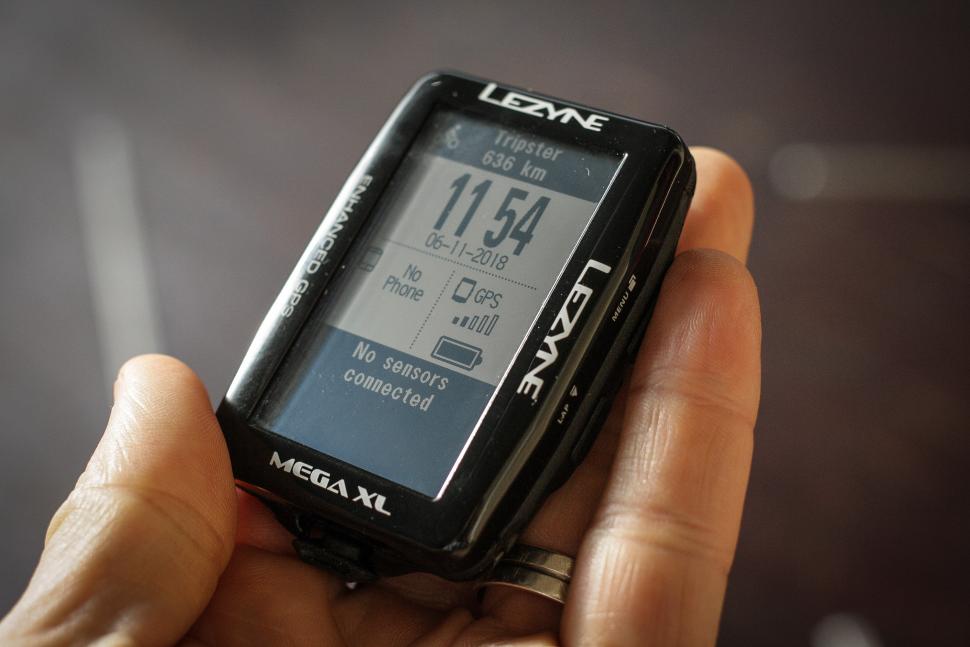
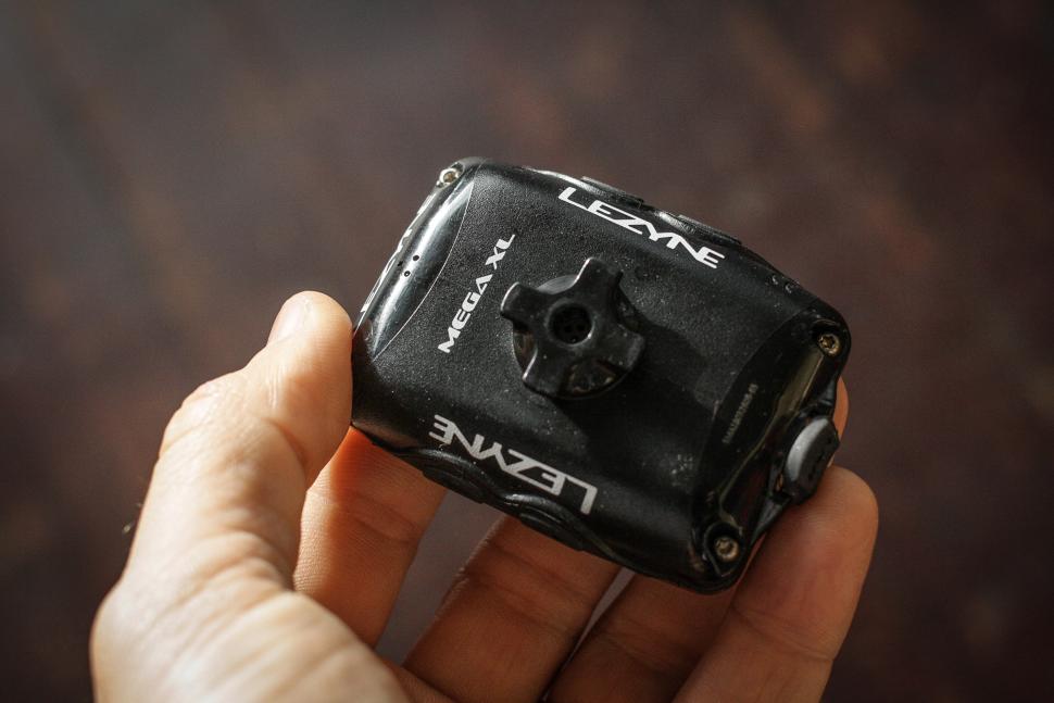
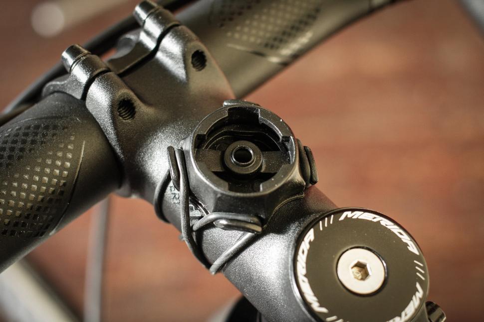
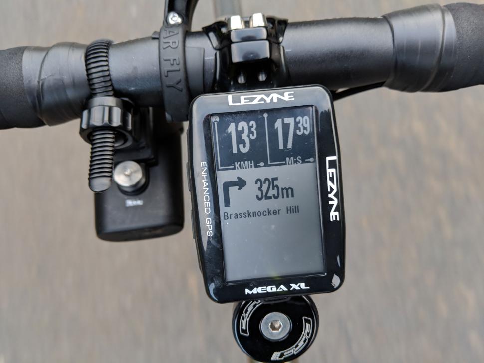
The Mega XL is a fairly chunky GPS. The monochrome LCD screen is quite big, with a 240x400 resolution, and the unit is also fairly deep, to house the big battery that it contains. It doesn't feel over-large, though, and it's happy enough sitting on your stem on the supplied mount without getting in the way.
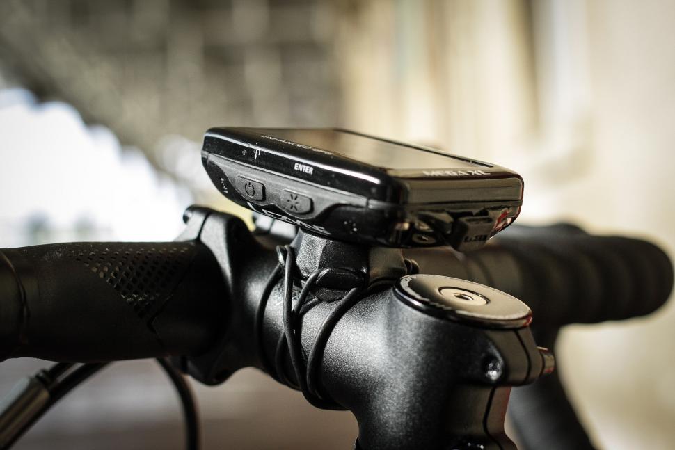
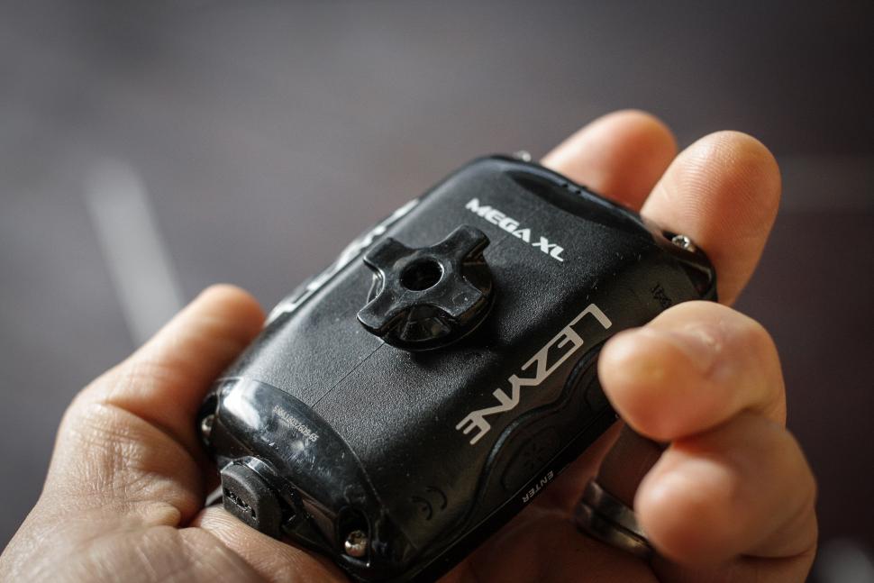
There's an out-front mount too if you prefer that. Lezyne's mount is a one-eighth turn, so you offer up the computer at 45° and twist it into place. You need to apply a fair bit of downward pressure to get it to twist and lock, but the upshot is that it feels very secure once it's in. It's definitely better than the Garmin quarter-turn, which doesn't have anywhere near as positive an action and doesn't feel as secure.


The Mega XL can be mounted portrait or landscape and you can change the settings to display in either orientation. Personally I preferred it in portrait mode, mostly because that means you get a bit more map ahead of you when you're following a route. But it's perfectly functional in both orientations. Design-wise I wouldn't say it was as polished as units from the likes of Garmin and Wahoo; the Lezyne computers have come on quite a lot in design since they launched, but it has a slightly industrial feel to it.
In use: Lots of data, easy to configure on the app
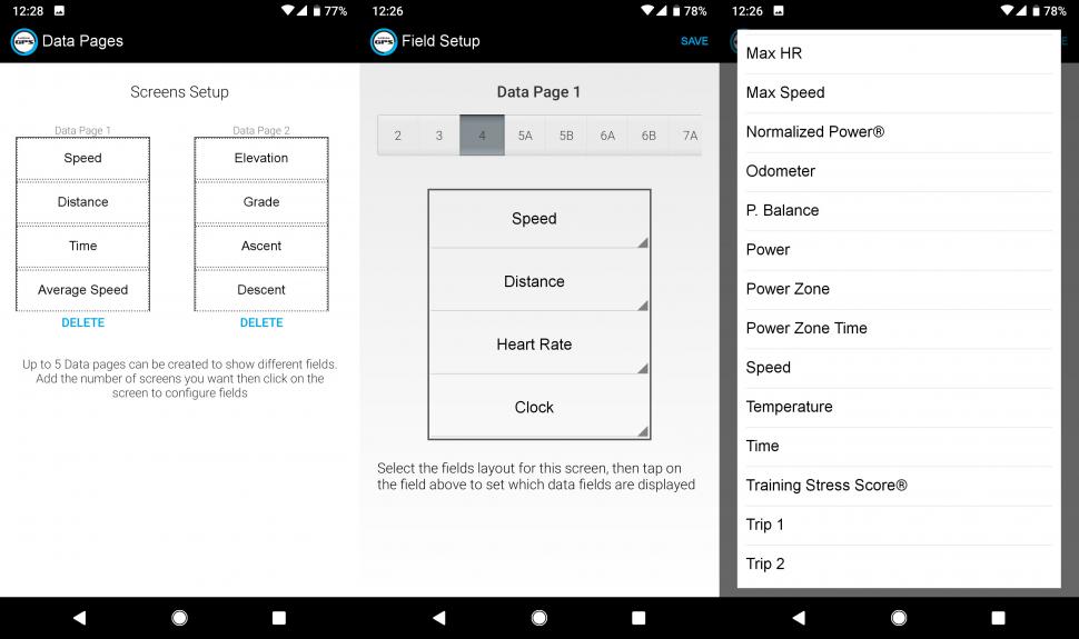
The Mega XL can have up to five pages of data, with up to 10 data fields on each. In the unlikely event that you regularly like to look at 51 different metrics on a ride, I guess you're out of luck, but realistically there's enough space there for anyone. If you've paired your phone to the GPS you can change the displays through the app, which is about a thousand times quicker than trying to do it on the on-screen menus. It has the additional benefit that you can see all the data screens on one page, so it's much easier to remember what you've put on them all.
You can also change the general settings on the device – screen settings, navigation, personal data, and so on – so you rarely need to dive into the menus on the device itself. That's good news, because the Lezyne user interface, although it has certainly improved over the last couple of years, still has quite a functional feel, as though it's been designed by an engineer rather than someone thinking about the user experience. It's usable, but it's not as friendly as some of the alternatives.
The Mega XL pairs to Bluetooth and ANT+ sensors. I successfully paired it with Lezyne's own heart rate strap on Bluetooth, a Wahoo TICKR strap on ANT+, Garmin Vector 2 pedals on ANT+ and a Garmin cadence sensor on ANT+. The connection was reliable, although getting the Bluetooth pairing working was more difficult, possibly because the unit also uses Bluetooth for talking to the smartphone app. Anyway, it's likely that whatever sensors you have will work, and if you get the Loaded bundle (£270) there's a Lezyne HRM strap and speed/cadence sensor included with the GPS, both of which are fine.
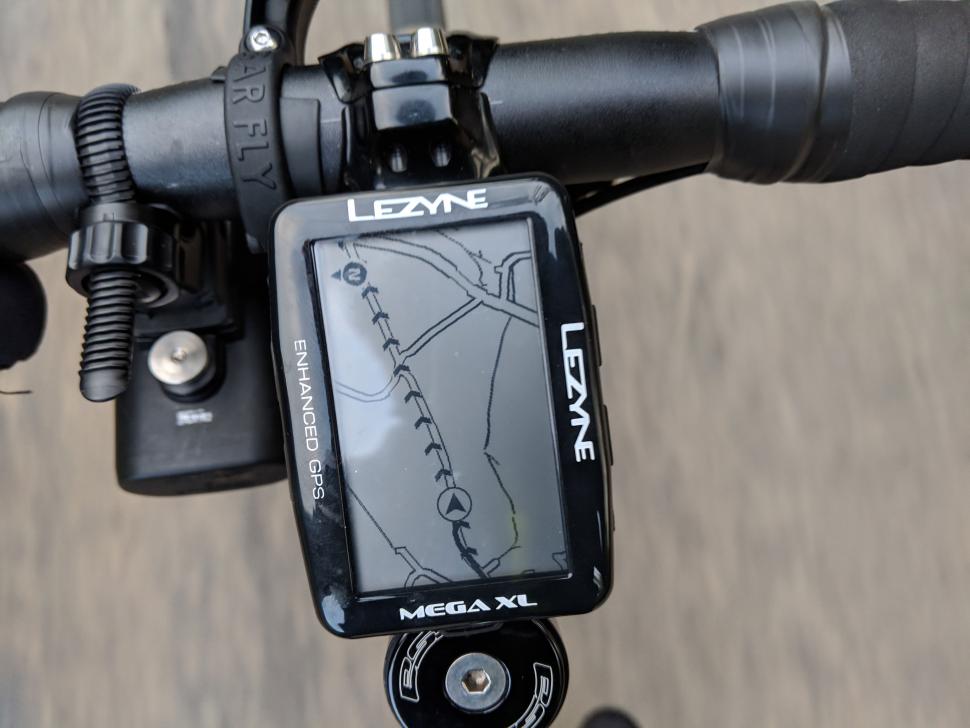
Out on the road the Mega XL is easy to use. The location fix from the GPS and GLONLASS networks is nice and quick. The screen is clear in all light conditions, and in riding mode the enter button turns the backlight on and off as and when you need it. The two topmost buttons – which are quite small and can be a fiddle in gloves – toggle through the data screens, and also the mapping and navigation screens if you're following a route. There's a built-in altimetric barometer for good-quality altitude data.
As a general-use computer for recording your rides it's good, but there are plenty of other, cheaper options that will do that sort of thing. If you're looking at the Mega XL you're probably doing so because it'll do mapping and routing, or because it has a long battery life, or both. Let's look at the mapping first.
Downloading mapping: easy on desktop, slow on mobile
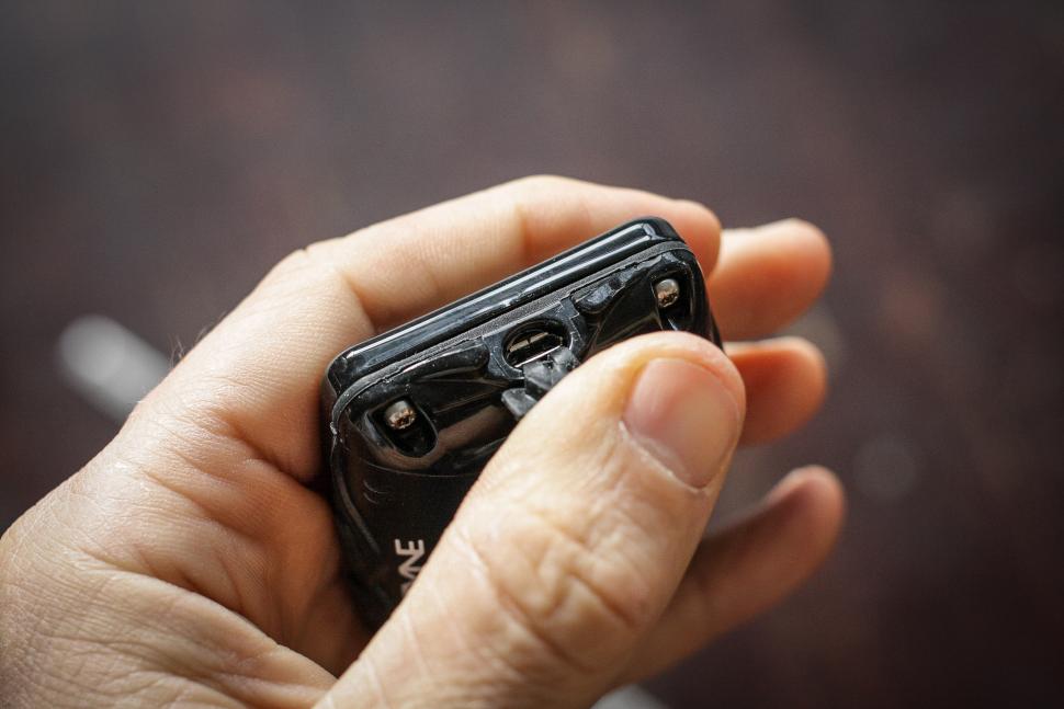
To get maps on your Mega XL you need to download and transfer them. You can do this in one of two ways. On the desktop (Lezyne Root) you can use the mapping tool to select an area and download it as a file, then drag it on to the GPS via a USB connection; the Mega XL mounts as a drive in a similar way to a Garmin. On the phone app you can do effectively the same thing, using the Bluetooth connection to transfer the mapping to the device.
Downloading and syncing maps from the phone app works, but it's pretty slow. A decent-sized map tile takes a few minutes to generate on the app, and as much as 10 minutes to transfer to the GPS. It's definitely better to do it on desktop when the Mega XL is plugged in, and the phone app acknowledges as much, suggesting the desktop route as the quicker option in a pop-up alert. But if you're out and about and you need a map you don't have, it's possible to get it provided you've got a data connection.
The map segments themselves aren't particularly big files, so you can get plenty of area covered. The biggest map file I've generated is only about 4Mb and covers a square about 50 miles to one side, so with around 60Mb of free space on the Mega XL you should be able to cover somewhere in the region of 40,000 square miles. There's no easy way to see what is and isn't mapped, although that will be coming on the next update of the smartphone app.
Route generation a mixed bag; good on the app
It's fair to say that Lezyne's desktop offering lags behind most of its competitors in terms of usability, and that's being kind. You have to add all your waypoints, and then calculate a route. If you don't get the route you want you can move the waypoints, or you can add more and play around with their order by clicking buttons to make them go up and down in a big list. It feels very convoluted compared with, say, Strava, where you can just drag the route about until you like it. It's not that it doesn't create good routes – it does, generally – just that the interface doesn't make it easy.
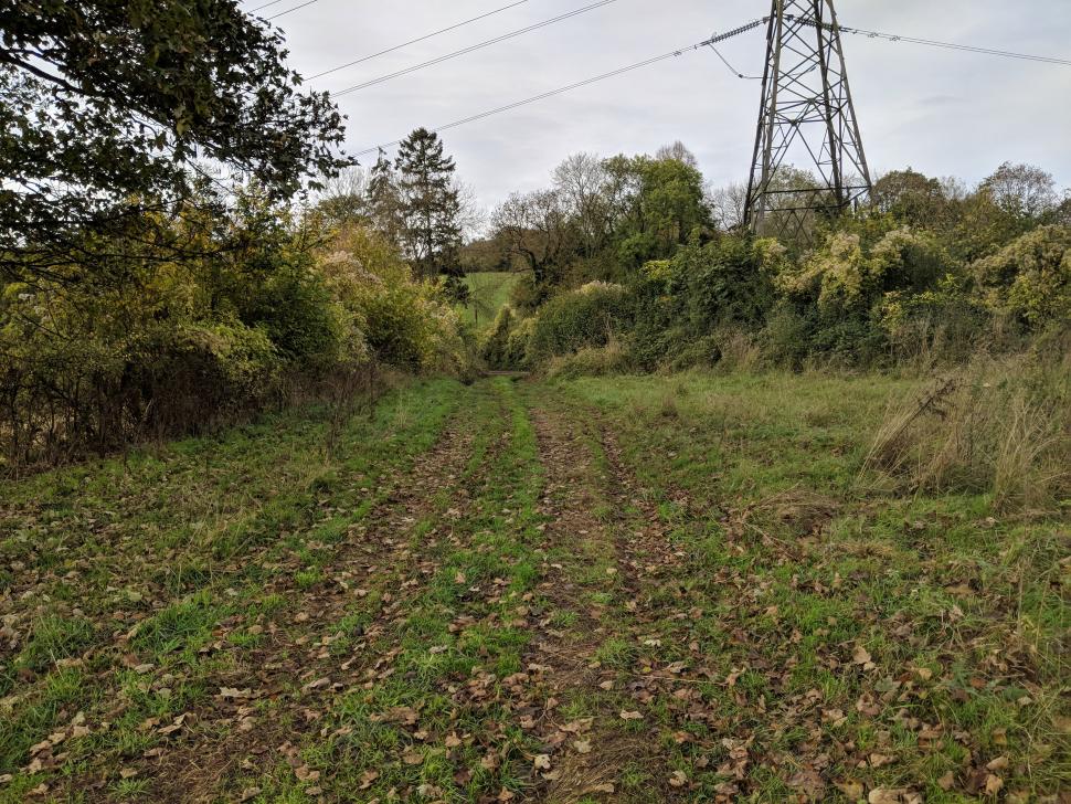
The routing algorithm favours smaller roads over bigger ones a lot of the time, to the extent that sometimes it'll have you heading off down something like this:
That doesn't happen very often, to be fair. But if you want to head into town on a fairly major road it can be hard to make the route snap to it, and because you can't drag it around in the editor you're stuck with adding new waypoints, changing their order and recalculating the route. It's a faff. Or you can just ignore the route at that point, of course.
If you really want to create a route in the Lezyne environment, because you really want the turn-by-turn directions, then the best place to do it is the Lezyne Ally app on your phone. Instead of adding all the points and calculating the route, you do it point by point. The app calculates the route, and even gives you a couple of options to choose between points. You can drag the individual points about, too, and the route will be recalculated. It's altogether a much better experience, albeit on a smaller screen. It does beg the question: why doesn't the desktop routing work in the same way? Please make it better, Lezyne.
I don't generally use turn-by-turn notifications, so most of the time I was happy enough importing routes from Strava. If you want turn-by-turn, and you want a better UI than the Lezyne GPS Root one, you can create routes at RideWithGPS and export a .tcx file, which when imported into Lezyne GPS Root should give you the directions you want.
> Buyer's Guide: 11 of the best GPS cycling computers
If you've created a route on desktop then it'll automatically sync with your phone app, and if you've created it on the phone it's there already. Then it's just a case of pairing with the GPS, selecting the route and hitting go. If you're not at the start of the route then it'll ask if you want directions there, and once you reach the route you'll get a series of chevrons to follow on the map and turn-by-turn directions with audio notifications at 100m, 50m and 25m, if you've created the route in Lezyne's ecosystem. You'll see them on the map and navigation screens and you can set the unit to pop them up on the data screens too.
Once you've started the navigation you can turn Bluetooth off on your phone to save battery if you like; the routing doesn't need the phone although if you go off-route it won't redirect you without a paired phone and a data connection. I tended to turn the rerouting off anyway. If you've imported a route from another platform you generally just get the line, and not the directions.
I found the routing easy to use and easy to follow. The map display is basic, but there's enough detail that I was never really in any doubt where I was going. There are three levels of zoom available with a long press on the enter key. Most of the time I was happiest just following the line, having created a route on Strava where I found it easier; I don't generally feel I need turn-by-turn instructions though the Lezyne ones worked pretty well.
One thing you can't do with the mapping on the Lezyne is move it around: you're centred on the map and it moves around you. That's fine most of the time, but can be an issue if you find a problem with your route (a closed road, or a muddy byway you don't fancy on your road bike) and you need to work your way around it. The Mega XL could do with either the capability to move the map around, or a zoomed-out screen where you can see your position in relation to the route you're following.
Battery life: prodigious
Once you've started your ride it's likely your legs will give out before the battery does. Lezyne claims a battery life of up to 48 hours for this unit. In real life, when you're pairing to your phone and sensors, and using the backlight, you're not going to get too near that. But even so, this GPS runs for a long, long time before it needs recharging. I've had about 30 hours out of it in a mixed use scenario: sometimes with sensors paired, sometimes with the phone paired, sometimes using the backlight.
If you were prudent with your connections and your lighting needs you'd probably make it up to around 36 hours, which means it might get you to the end of a 600km audax on one charge, or a week of fairly extensive riding on a cycling holiday. That's untouchable (I think) from a unit with mapping right now, so if long battery life is top of your list, so should this be. Most people who ride long distances have a charging strategy that'll involve a battery pack or a dynamo or both; the Mega XL is happy to charge from Micro USB as it's being used, and you can get a fair amount of charge into it at a cafe stop too if you prefer to do that. But you won't need to spend as much time worrying about it, and it's not going to suck up as much of your backup battery, leaving more for your phone.
Bottom line is: it's the class leader here. Bigger trekking-orientated units that take AA cells, such as Garmin's eTrex, will last a full day from one set of batteries, but even they won't go as long as the Mega XL.
The firmware seems to be pretty robust, too. I've recorded some long rides on the Mega XL and deliberately kept it running over the course of a day, and I've never had it freeze on me or corrupt my data. So if you are planning a long ride you can expect the Lezyne to log it properly.
Notifications: if you want them, there they are
Once you've paired your Mega XL to your phone you can allow it to send notifications to the GPS. So if you're expecting a super-important email then you could have the notification pop up on the screen so you can address it. Mostly I just found it annoying, and turned it off. But it's there if you want it, and I'm sure some people will find it useful.
Lezyne Track: useful for peace of mind
Lezyne offers free tracking functionality, so you can share your location with friends or family. It's not a gimmick: Trek-Segafredo directeur sportif Steven de Jonghe quite possibly owes his life to the Strava equivalent after an accident left him unconscious in a ravine on a training ride.
Lezyne's tracking works well: you can turn it on and off, and add contacts who can see you. It works from the phone app rather than specifically from the GPS; when you start a ride your contacts will automatically be emailed to give them a tracking link. You get a lot more data than you do just by sharing your location on Google Maps, for example, so it's easier to see if someone's actually moving and how their ride is progressing. It relies on a cellular data connection, so it won't work all the time if you're heading out into wildest Wales, say, but that's a shortcoming of everything short of a satellite tracker.
Finishing a ride: BTLE makes for slow uploads
When you've finished a ride you can use the phone app to sync your ride with Strava, TrainingPeaks and Today's Plan. I use Strava and I can confirm that the sync works, but it's very slow at times. Uploading a long ride (say, over 100km) takes a good few minutes. It's sufficiently lethargic that I have on occasion found it quicker just to plug the GPS into the laptop when I've got home and manually upload the file. Certainly if your ride is 200km or more, that's pretty much the default workflow if you don't want to be waiting around for ages.
It's not like it doesn't work, but a Bluetooth sync from my Garmin Edge 520 is more or less instantaneous, and even the Xplova X3 I tested recently, which isn't exactly quick to sync, is finished long before the Lezyne. The main reason for this appears to be that the phone pairing is done over BTLE (Bluteooth Low Energy) rather than full-fat Bluetooth, meaning that the data transfer rate is much slower. The payoff for this is longer battery run-times, and as I've noted above, the Mega XL is really in a class of its own there. So if the run-time is the USP for you, you'll probably be able to live with the slow uploads.
Things I didn't try: workouts, Strava Live segments
I'm not on Strava Summit so Live segments aren't something I use (they weren't anyway, even when I was), but the Mega XL supports them. You can sync your starred segments in Strava, and then you get some live information when you ride them: the GPS will tell you if one is coming up, and you'll get a distance to go and a timer on the segment.
You can import workouts from TrainingPeaks or Today's Plan and follow them on the head unit. I can't imagine that it's going to be a major selling point for the Mega XL, but the functionality is there if you want to try it. I'm busy Zwifting on a big screen when I'm indoors, so it didn't really appeal.
Value - about what you'd expect to pay
At £180 it's in the ballpark of computers such as the Garmin Edge 130 and Mio Cyclo 210 – it does some things better and others not as well, but the features are comparable, even if the battery life is not.
Overall: not without some issues, but a solid offering
There's nothing that the Mega XL has issues with – poor desktop route creation, slow activity uploading, the slightly industrial feel to the unit itself and the user interface – that would prevent me from recommending it if you're looking for a computer that will let you follow a route for a long, long time. You might not get the claimed 48 hours out of it, but the Mega XL will still be beeping at you long after everything else has died.
The routing on the device is simple but effective, and the smartphone app gives you plenty of control without having to dive into the complicated menus.
Realistically, this GPS is going to appeal most if your rides extend beyond the battery life of the core of the market. Beyond about 12 hours your options are limited, and past 24 they more or less dry up completely. The Mega XL isn't perfect, but it's very good as a long distance companion.
Verdict
Huge battery life and usable routing make the Mega XL a very good choice if you're going long
road.cc test report
Make and model: Lezyne Mega XL GPS computer
Size tested: 57.5mm (W) x 78.3mm (L) x 26.6mm (H)
Tell us what the product is for and who it's aimed at. What do the manufacturers say about it? How does that compare to your own feelings about it?
Lezyne says, "Designed and engineered in-house utilizing the ultimate in cycling GPS technology, this is a must have device for serious riders. It has a large, 2.7-inch 240x400 high-resolution screen with the option of vertical or horizontal viewing. It can simultaneously pair with Bluetooth Smart or ANT+™ enabled power meters, heart rate monitors and speed/cadence sensors, in addition to compatible electronic drivetrains. When paired with an iOS or Android handheld through the free Lezyne Ally V2 app, the device provides turn-by-turn navigation and phone notifications (incoming calls, texts and message app notifications). It has on-screen preloaded maps, provides turn-by-turn navigation, off-line navigation and can be instantly customized. Live tracking (Lezyne Track) can be activated in the app to let friends and family follow rides in real-time. Furthermore, the device is equipped with GPS/GLONASS, a barometer and an accelerometer. Combined, these greatly improve accuracy and data recording. It also has best-in-class battery runtime of up to 48 hours. All this and a whole lot more."
Tell us some more about the technical aspects of the product?
From Lezyne:
Durable, composite construction
Super accurate, advanced data recording system combines GPS plus Glonass satellites
Simultaneous ANT+ and Bluetooth® Smart connectivity
Multiple real-time features when paired to the Lezyne Ally app
Barometer and accelerometer
Simple setup through Lezyne Ally phone app
Import .tcx and gpx. Files
Trainer Mode
Multiple bike profiles
Full navigation
Custom route building
Intuitive four button operation
Lithium polymer battery provides up to 48 hours of runtime
Micro USB rechargeable
Stores up to 800 hours of ride data
Customizable fields and page count (up to 10 fields)
On screen preloaded maps
Custom alerts and auto presets
Extremely weather resistant
Includes X-Lock Standard Mount
SPECS
COLORS: Black
WEIGHT: 83g
RUNTIME: 48 hours
MEMORY: 800 hours max
DIMENSIONS:
Computer 57.5mm (W) x 78.3mm (L) x 26.6mm (H)
Screen: 35.3mm (W) x 58.8mm (L)
CONNECTIVITY:
Receive text, email, phone call and message app notifications when paired to smartphone
Sync rides via Bluetooth Smart to the Lezyne Ally phone app
Instant download of ride files (.fit) via plug-and-play flash drive technology (Windows/Mac) and upload directly to GPS Root website for ride analysis
Auto-sync ride data to Strava, TrainingPeaks and Today's Plan
Pairs with Bluetooth Smart or ANT+ enabled heart rate monitors, cadence/speed sensors and power meters
Connects with compatible electronic drivetrains
Turn-by-turn navigation
Off-line maps and rerouting
Follow structured workouts from Today's Plan and TrainingPeaks
DISPLAY DATA:
Map
Turn-by-turn navigation
Live Tracking icon
Strava Live Segments
Structured Workout
Heart Rate*: Current, Average, Max.
Cadence*: Current, Average
Power* (6 data display options)
Training Specific Fields: TSS®, NP®, IF®
Electronic drivetrain data
Speed: Current, Average, Max./li>
Distance: Current, Trip Total, Trip 2, Odometer
Time: Ride Time, Clock
Date
Laps and lap averages
Elevation: Ascent, Descent, Current
Grade
Calories
Temperature
GPS signal strength
Battery life indicator for device and paired devices
Connected devices icons
Bread crumb trail page
LOADED OPTIONS:
GPS Computer
Heart Rate Flow Sensor
Cadence Speed Flow Sensor
Direct X-Lock Standard Mount
Micro USB Charging Cable
Rate the product for quality of construction:
8/10
Nicely made, the mount design is especially good.
Rate the product for performance:
7/10
Overall, with everything (app and desktop) considered: good.
Rate the product for durability:
9/10
Chunky, feels built to take a few knocks.
Rate the product for weight (if applicable)
7/10
Not the lightest but it's only 81g.
Rate the product for value:
5/10
About what you'd expect to pay given the features.
Tell us how the product performed overall when used for its designed purpose
Overall it's good, and if you're interested in routing and long rides – and you probably would be if you're looking at the Mega XL – then it's very good.
Tell us what you particularly liked about the product
Battery life, clear screen, routing on the app and unit works well, mount is excellent, well built.
Tell us what you particularly disliked about the product
Industrial feel to the design and UI, desktop route planning is poor, upload of activities is very slow.
How does the price compare to that of similar products in the market, including ones recently tested on road.cc?
It's in the ballpark of computers such as the Garmin Edge 130 and Mio Cyclo 210 – it does some things better and others not as well, but the features are comparable, even if the battery life is not.
Did you enjoy using the product? A bit fiddly at times but overall yes.
Would you consider buying the product? If I was planning a Super Randonneur series, yes.
Would you recommend the product to a friend? If they liked long rides, yes.
Use this box to explain your overall score
Probably overall, taking everyone's use cases into account, it'd be more like a 7. But the Mega XL is really defined by its battery life and routing/mapping, which narrows its appeal. For people looking for a computer for that sort of riding – following longer routes – it performs very well, even with its foibles.
About the tester
Age: 45
I usually ride: whatever I'm testing... My best bike is: Kinesis Tripster ATR, Merida Scultura
I've been riding for: Over 20 years I ride: Every day I would class myself as: Experienced
I regularly do the following types of riding: road racing, time trialling, cyclo-cross, commuting, touring, club rides, sportives, general fitness riding, fixed/singlespeed, mountain biking, Mountain Bike Bog Snorkelling, track

Dave is a founding father of road.cc, having previously worked on Cycling Plus and What Mountain Bike magazines back in the day. He also writes about e-bikes for our sister publication ebiketips. He's won three mountain bike bog snorkelling World Championships, and races at the back of the third cats.
Latest Comments
- ktache 23 min 49 sec ago
Id forgotten that I got a second hand set of project two's for my getting to work bike over twenty years back.
- ktache 28 min 46 sec ago
Not many animals cause grinding noises when underneath a vehicle.
- eburtthebike 48 min 26 sec ago
I listened to the BBC R4 prog "Should cyclists stay in their lane" and it was pretty much what you'd expect from the BBC, a well-informed cyclist...
- eburtthebike 1 hour 6 min ago
Of course you don't actually want to spend money intended for infrastructure on infrastructure, you want to spend it on plans for infrastructure,...
- Veganpotter 1 hour 20 min ago
My bet is that all these tires popping off are from people with bad pressure gauges or they're simply just putting too much air in on purpose. ...
- Hirsute 1 hour 43 min ago
You have to add images via a reply to yourself after the topic is created. One at a time too.
- Hirsute 1 hour 45 min ago
“Plus, riders who pair CarBack to their smartphone using the Trek Accessory app can enjoy even more features, including the ability to see the...
- chrisonabike 2 hours 36 min ago
David9694 - you were right! These new autonomous vehicles really are conspiring to run out of control!...
- HoarseMann 3 hours 7 min ago
Decathlon have the Garmin Varia RTL515 on offer at the moment for £129.99: https://www.decathlon.co.uk/p/rearview-radar-varia-rtl515-65-lumens/_/R-...
- Rendel Harris 4 hours 18 min ago
So when you said "all Jews" you didn't actually mean all Jews, just religious ones. However even that distinction is erroneous, as you must surely...


Add new comment
12 comments
I've had one of these since August now. Great little unit, very solidly built and the screen is excellent in all light conditions. The app and setup is pretty straightforward and the navigation works fine, although I've had the BT connection with my phone be a bit hit-and-miss. The battery life is great, it lasted two weeks in Germany without needing to be charged at all, and though the included mount is decent I think it's worth shelling out for the out-front mount for a more natural position.
The only problem I've had is that my screen glitches out in cold conditions. I've talked to Lezyne and this seems to be a manufacturing defect so I'll be getting a warranty replacement. Bit of a bummer, but these things happen. I don't know about value at the standard price, but due to a few discounts I got mine for about £137, which I'd say is a bargain for a unit like this.
Thanks very much for the speedy response!
I'm increasingly cheesed off with my Garmin, so I intend to get a look at this new Lezyne soon. >40 hours of battery life sounds heavenly.
One important thing that you fail to mention in the review...you cannot run third party gpx files on this device unless you are paired to your phone. So, if you intend to do a long multi-day event, without way marking, or a 400km plus Audax where a gpx has been provided, you must save the route in the clunky phone app and pair your phone to the head unit. You cannot navigate third party gpx files otherwise. How many phones have a battery that will last more than 20hours or so with Bluetooth running for the whole time?
While you do need your phone to start the navigation file, the phone can actually be turned off once navigating. Here's an article which shows what does and doesn't need a phone connection: https://support.lezyne.com/hc/en-us/articles/360003855474-Does-my-GPS-Device-need-a-Phone-Connection-
60 MB of storage sounds rather mean in the early 21st century. When I go touring I like to load the whole region that I'm going to, in advance. That means several hundred MB to maybe a GB if they're OSM/OpenFietsMaps. Dave hasn't told us what kinds of maps it uses, so I'd better hop off to Rainmaker's and Lezyne's websites and find out. 60 MB is plenty for routes/tracks, but not for big maps.
Edit: On the Lezyne website, I see that I can download rectangles from OSM. I have made a thin one that's about 500 miles long, so presumably 80 miles wide. If you're doing a thousand mile trip, its unlikely that you'll stay within a 40 or 80 mile wide strip. At least they're proper maps, not Google maps.
Hi janusz0,
Just for clarity, every map that gets downloaded to the device uses Open Street Map (OSM) data. You are able to download mutliple maps to cover a large area or multiple cities, and the GPS will automatically know which map to use based on your location. We're able to do this with a proprietary method of compression which makes each map file VERY small.
Sounds good - would you mind if I asked how the compression compares with straight/compressed PBF ?
"Design-wise I wouldn't say it was as polished as units from the likes of Garmin and Yahoo"
What - the 1990s search engine has moved into GPS cycle computers....?!?
fixed now!
I had one of the previous 2nd generation smaller Lezyne GPS....so happy with it (apart from no mapping) that as soon as a Mega XL came out there...I purchased one... Fabulous bit of kit, good navigation ( I plot my routes with Plotaroute.com and upload via Lezyne root) and great battery life. I've downloaded maps to the device, which is a cinch and have all of England plus East and West Flanders as well as Nord Pays de Calais and still only used half of the memory. Clearly if you only download your local mapped area where you cycle and any sportive areas you are riding then you'll have tons of space. I must agree with BTLE being a "slow" upload but to be honest when back from a ride, I save and upload before anything else then after setting about with the post ride faffing with your kit off etc....it's done...so not that much of an issue. A decent unit for the price and I see that AG2R are using these in the Peloton next year (Cydance have used them this year during development) I'd certainly recommend one of these....
I have the smaller Lezyne Macro GPS unit, and generally it's brilliant, but trying to use the Lezyne Root desktop tool for mapping is absolutely not to be considered - it's horrendous. The Lezyne Ally app for mobile is marginally better but still a real faff. I use other GPS mapping software and export the file, then import it to the Ally app to sync with the unit. These Lezyne GPS units are great and really good value but the associated desktop and mobile software is a huge drawback.
What really anoys me about all the current GPS units (that I know of) is the sound. Can someone please try to build in a decent speaker! The beeps are so old...