

- News
- Reviews
- Bikes
- Accessories
- Accessories - misc
- Computer mounts
- Bags
- Bar ends
- Bike bags & cases
- Bottle cages
- Bottles
- Cameras
- Car racks
- Child seats
- Computers
- Glasses
- GPS units
- Helmets
- Lights - front
- Lights - rear
- Lights - sets
- Locks
- Mirrors
- Mudguards
- Racks
- Pumps & CO2 inflators
- Puncture kits
- Reflectives
- Smart watches
- Stands and racks
- Trailers
- Clothing
- Components
- Bar tape & grips
- Bottom brackets
- Brake & gear cables
- Brake & STI levers
- Brake pads & spares
- Brakes
- Cassettes & freewheels
- Chains
- Chainsets & chainrings
- Derailleurs - front
- Derailleurs - rear
- Forks
- Gear levers & shifters
- Groupsets
- Handlebars & extensions
- Headsets
- Hubs
- Inner tubes
- Pedals
- Quick releases & skewers
- Saddles
- Seatposts
- Stems
- Wheels
- Tyres
- Health, fitness and nutrition
- Tools and workshop
- Miscellaneous
- Buyers Guides
- Features
- Forum
- Recommends
- Podcast
review


£429.99
VERDICT:
Top of the pile for mapping-capable, bar-mounted GPS units, but not without its limitations.
Weight:
105g
Contact:
www.madison.co.uk
At road.cc every product is thoroughly tested for as long as it takes to get a proper insight into how well it works. Our reviewers are experienced cyclists that we trust to be objective. While we strive to ensure that opinions expressed are backed up by facts, reviews are by their nature an informed opinion, not a definitive verdict. We don't intentionally try to break anything (except locks) but we do try to look for weak points in any design. The overall score is not just an average of the other scores: it reflects both a product's function and value – with value determined by how a product compares with items of similar spec, quality, and price.
What the road.cc scores meanGood scores are more common than bad, because fortunately good products are more common than bad.
- Exceptional
- Excellent
- Very Good
- Good
- Quite good
- Average
- Not so good
- Poor
- Bad
- Appalling
The Garmin Edge 810 does enough to justify its place at the very top of the bike GPS pile. If you want a navigation-enabled, fully waterproof, mapping GPS computer that you can stick on your bars then it's pretty much the best of the bunch.
That being said, the extra features of the 810 over the previous model, the 800, feel a bit like they've been rushed, and Garmin haven't really addressed some of the issues that the 800 had, either. As such, the older, cheaper 800 will still be a better bet for anyone who doesn't need the connectivity of the new model, and we can't help feeling that new models with significantly better screens – and low-power Bluetooth – can't be far away.
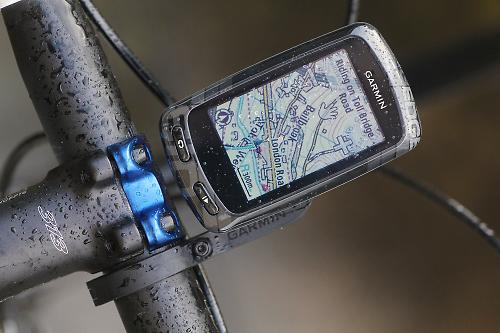
From a distance you'd be hard pressed to tell the 800 and 810 apart: it uses the same case, and features the same 160x240 pixel LCD touchscreen. Anyone who's used to watching HD films on their OLED mobile phone screen might be put off by the low resolution, but it's for a reason. LCD uses much less power than OLED, and is viewable without a backlight, meaning that the battery life is much improved. Garmin claim 17 hours maximum for the 810; more on that later. The resistive screen also means that you can swipe and press wearing gloves, which isn't possible with capacitive screens unless your gloves have a conductive fabric insert.
Pairing with a phone
Obviously the 810 has a GPS chip, and ANT+ connectivity for speed/cadence sensors, power meters and such. The big news is that the 810 is Bluetooth enabled too. That means you can pair it with your phone, using the Garmin Connect app.
And why would you want to do that? Well, you can set your unit to instantly sync any ride as soon as you finish, meaning you don't have to do it in chunks when you remember. Also, you can set up live tracking on Garmin Connect, to show your progress on a ride in real time. The Connect App makes stored routes on the web service available too, so they're always available to your device. Weather alerts are also available via the Bluetooth interface.
You might decide that you don't actually need any of that Bluetooth functionality, in which case you might be better off looking at the 800: the extra connectivity is really the headline difference between the two models. Personally I found that I didn't bother with the Bluetooth ride syncing after a while, as I was happy to wait to upload rides when the unit needed charging. Your mileage may vary there.
Husband tracker
Similarly, I didn't use the route syncing very much. The live tracking is something I do use though, on a regular basis. My wife likes to know where I am on longer rides (or, at least, to know that she can know) and the 810 makes that easy. Previously I'd used an open source geotracker on my phone, but the Garmin offering is certainly a lot slicker.

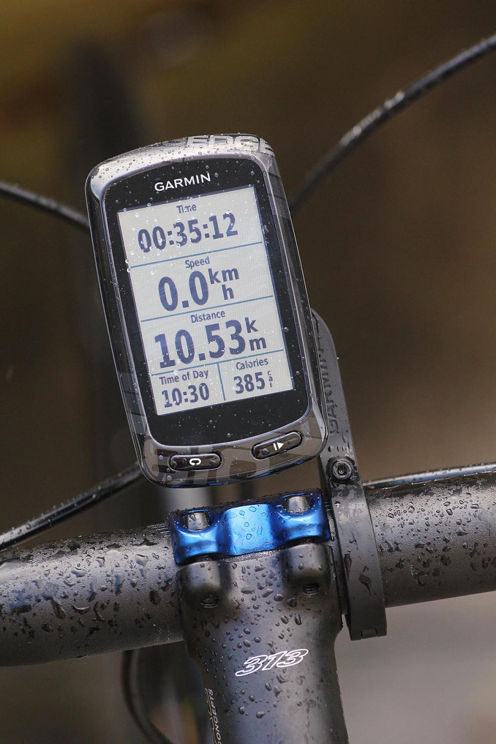
At its most basic the 810 works like a cycle computer. Turn it on, hit 'Ride', then press go, and off you trot. You'll get a data screen of the kinds of things you're used to seeing on a computer, and you can leave it at that if you like.
The GPS picks up your position very quickly – though not as quickly as the Edge 510 which also uses GLONASS satellites – and like all GPS units I've used it's best to wait until it's placed you before you set out, as they find it much more difficult to lock once you're moving. GPS accuracy is very good: better than my phone, and less likely to be confused by reflections from buildings or obscured by trees, in my experience.
There's lots more to it than just the first screen though: the Garmin 810 has a positively bewildering array of data functions and screens that would keep even the most die-hard statto busy for weeks. For a start, two more data screens are just a swipe away. And each of those three screens is completely configurable to show you just the data you want.
You can set up as many as ten different bike profiles on the computer, one for each of your bikes, and different activity profiles for the different types of riding you do. Each of these profiles can have different data pages, if you want. I'm not going to go through the full range of data fields available, because it's a long list - there are nearly 90 different data types you can display, some of which depend on other sensors such as power meters and cadence sensors. Page 19 of the user manual lists them all.
That ease of setting up different profiles for different bikes and types of riding is a major advantage over the Edge 800, and the profile customisation also extends to ANT+ devices, so you can pair your PowerTap hub on the road bike but not on the mountain bike, for example. If you have a stable of bikes, it's a lot better than its predecessor.
You can set the 810 to record laps, either at a certain point, or a certain distance, or a certain time. There's also a virtual partner screen as well, which allows you to 'race' against another, virtual, rider. You can set the average speed of your opponent, and the Garmin will show you how far ahead or behind you are. Virtual partner is also available when you're following a track you've previously ridden, so you can compete against yourself; it's good to have that information in real time, although that's something that's also available on Strava now, for a premium.
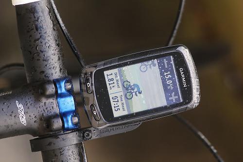
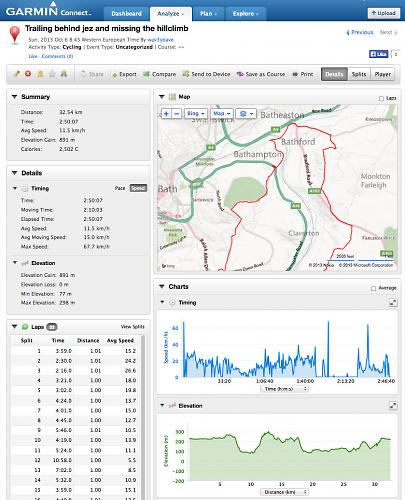
Mapping & routing
And all that's without using the 810's mapping capabilities. Our unit came preloaded with Garmin's base map, and also Ordnance Survey maps down to 1:50,000 Landranger. That makes for very accurate and reliable mapping across the UK, both on and off road, and also allows you to follow routes on the device.
There's a number of ways to create routes for the 810. The Garmin Connect website allows you to create routes, or you can use a third-party mapping site such as www.ridewithgps.com and export a .gpx or .tcx file. Or, you can use a web service to get a similar file from Google Maps. Uploading the route from Garmin Connect is straightforward; getting the data in from other locations is a bit more circuitous but still fairly easy.
As well as using a pre-loaded route the 810 lets you navigate to a point of interest; you can pick from a list stored on the device.
Upload the right kind of file and the 810 will offer you turn-by-turn directions, and you can even get custom notifications as you go. There's plenty of advice online as to what services are best for creating these routes. I've had the best results exporting TCX files from RideWithGPS. Originally the 810 wouldn't read TCX files, despite the fact that the 800 did, but a firmware upgrade fixed that.
Navigation on the 810 (and 800) is one of the things that keeps the Garmin forums ticking over at a steady rate. There are a lengthy list of settings – both in the file creation and on the device – that you can alter to change the way the unit will route you, and how it will respond when you leave a course, but I have to say that I've more or less stopped using turn-by-turn navigation, As I find it to be a bit patchy, and most of the time it's surplus to requirements.
It's the re-routing aspects of the programming that seem to suffer the most. On a recent trip to Worcester I tried to navigate to Shrub Hill station (selected from the POI list) but decided to stay on the (quiet) A-road when the route went off into the lanes, as I was in a hurry to catch the train. Even after I'd entered Worcester the 810 was still trying to make me turn around to go back and pick up the quieter route, long after a car satnav would have snapped to the route being used. That's down to the configuration of the device on that ride, but I can't really think of an instance where I'd want the 810 to behave like that.
I found the 810's handling of re-routing to be inconsistent, which was the main reason it annoyed me. I tried fiddling with the routing settings to get it to work better, and mined the forums for advice, of which there is plenty, and had some success, but I was never 100% confident of being routed the right way on turn-by-turn. There are too many options for creating files to follow, and too many routing options on the GPS itself, with the upshot being a lot of trial and error before you find something that'll work consistently for you.
My current favoured method of routing with the 810 is to upload a route and then, in the route settings, check the 'Always show on map' option. That way I can ride, and follow the route, navigating as I go. I find the 1:50,000 mapping plenty good enough to pick the right road in practically every instance. With the unit on your bars, and the map on display, there's no real reason for you to go wrong.
Screen & battery life
The screen, as on the Edge 800, is acceptable rather than great. It suffers from a lack of contrast in bright conditions and reflections can make it difficult to see. When it's overcast, and at night, it's much better. The backlight can be adjusted in intensity (and duration after a screen touch) to help you in dim conditions, although that's another drain on the battery.
Garmin claim that battery is good for up to 17 hours. I haven't managed to eke 17 hours out of it, although I have got about 14 which is pretty good, and a lot better than any phone we can think of, especially if you were running it with the screen constantly on.
That said, the Bluetooth connectivity means the battery life takes a fairly significant hit. The 810 uses a Bluetooth 2.1 chipset rather than the newer, low-power Smart (4.0) standard which isn't universally supported on phones yet. That means more power drain when you're synced to your phone for live tracking, reducing the battery runtime by a couple of hours. I managed to drain the Edge 810 in just over 10 hours in the worst case scenario, a full day ride in sub-zero temperatures.
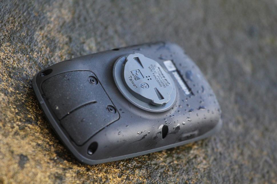
The device is fully waterproof and We've had no problems with it in deluge conditions, although on mucky backroads it's quite easy to scratch the screen by wiping a dirty glove over it, so it's best to stick a screen protector on.
Training
As well as being able to route you around, and record your rides for posterity, the 810 is a fully featured training aid too. ANT+ means it's compatible with a wide range of sensors, including Garmin's own; A heart rate monitor is most people's first step, and a speed-and-cadence sensor allows you to use the Garmin to track indoor miles on the turbo or rollers.
On top of that the Edge is configured to work with a wide range of power sensors, including (obviously) Garmin's new Vector power-measuring pedals. The latest firmware update for the unit will give you power and balance readings from the Vectors, and angular readings around the pedal stroke will be available soon. You can even stick the 810 on Garmin's wrist mount and go running with it; it's a bit bulky but should work fine.
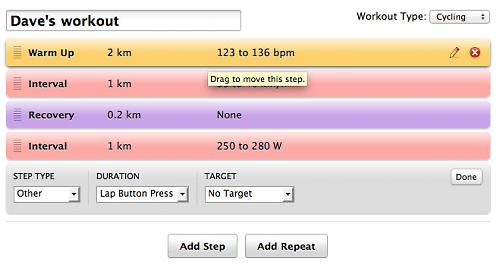
You can create training sessions to ride on the 810, either indoor or outdoor, using distance, heart rate, time – pretty much whatever you like. The easiest way to do it is via Garmin Connect, although you can also use third party training software such as TrainingPeaks.
Connect is one of Garmin's plus points: it's now very fully featured and easy to use. It doesn't go into the depth of the likes of TrainingPeaks, and it's not as instant as Strava, but it has a feature set that means you could use it as your main dashboard for training and riding quite easily. All your rides are logged, in detail, and you can access the statistics for them. You can also use it to store and track your personal physiology: weight, body fat, body water, bone mass and more. With a Bluetooth scale such as the Tanita BC-1000 Body Composition Monitor (that's what Garmin recommend) you can automatically update your stats.
Connect also has a calendar which allows you to track your training and plan future sessions. You can select a pre-made plan too; currently there are plenty of running ones and a few triathlon plans but only one for cycling, so that library needs to expand. You can set yourself goals for the year too: number of miles ridden, hours ridden, ride frequency and calories burnt are the current options.
Conclusion
All in all, with the unit and the web services on offer, the Edge 810 is a pretty compelling package, but it's far from perfect. What's really good is having a unit with usable mapping, with a good battery life, that's always on and accessible. Using your phone to log your riding is simplicity itself, but using it to navigate is a stop-start process that often involves digging in pockets and removing gloves. The 810 is much, much better for that. It's great for training, too: you can use it indoors or out, and you can set yourself a proper, calendared training schedule with complex intervals based on whatever metrics you're measuring.
And what's not so good? Well, the Bluetooth – both in the use of a 2.1 chipset and the fairly basic phone app – feels rushed, and the power hungry Bluetooth chip significantly affects battery life. The screen is okay but is in need of an overhaul, and the routing needs to work more consistently and be simpler to set up. The Ordnance Survey maps make a big difference, especially off-road; the base maps are okay but far from ideal.
If you're in the market for a mapping GPS and you've decided that it's an out-front unit you want, rather than relying on your phone, then the 810 succeeds the 800 as the best of the bunch. But with its limitations we can't help feeling it won't be top of the pile for long.
Verdict
Top of the pile for mapping-capable, bar-mounted GPS units, but not without its limitations.
road.cc test report
Make and model: Garmin Edge 810 (trail bundle)
Size tested: n/a
Tell us what the product is for, and who it's aimed at. What do the manufacturers say about it? How does that compare to your own feelings about it?
This Is Your Edge
The touchscreen Edge 810 is designed for the cyclist who wants it all '' navigation and advanced training capabilities in 1 device. Connected features through your smartphone include live tracking, social media sharing and weather. The 810 is compatible with optional detailed street or TOPO maps, so it can guide you during touring, commuting or other activities requiring onboard maps and navigation. Because it's GPS-enabled, Edge 810 provides accurate data and navigation capabilities, anywhere in the world.
Track Every Detail
In addition to mapping, Edge 810 records distance, speed metrics, ascent/descent, grade and more. It's also compatible with ANT+™ sensors that measure heart rate, speed/cadence and power. Activity profiles let you customize data fields and device settings based on cycling activity, such as road, mountain or touring. Switch profiles with a simple swipe of the touchscreen and the 810 will be set up to show the data for that ride.
Get Connected
Edge 810 offers a suite of connected features when paired with your smartphone (iPhone or Android™) and the Garmin Connect™ Mobile app. Get comprehensive, accurate ride data from a dedicated device, while saving your phone battery. Edge tracks the data and sends it to your phone using Bluetooth®. Stay connected and share all the details of your ride with friends, family and social media. Post an update immediately after your ride or race. Create the posts via your smartphone, and the ride data's already there, thanks to the interface with Garmin Connect Mobile.
Live Tracking
Live Tracking lets friends and family follow your races and training activities in real time. Invite followers using email or social media, and they can view your live data on Garmin Connect. Once they get your email invite, they can follow and see your stats and location on the map.
Weather
Get real-time weather conditions, forecasts and alerts (in areas with coverage) directly on the Edge 810 when paired with a smartphone and the Garmin Connect Mobile app. Your smartphone stays safe and dry, while the weather data you need is right at your fingertips.
Wireless Data Transfers
Instantly store, share and analyze every detail of your ride. Using Garmin Connect Mobile, you can wirelessly upload completed activities from your device as soon as you are finished. Activities can be automatically or manually uploaded. Once your ride has posted to Garmin Connect, your own 'connections' can view them. You can also search your courses and workouts4 stored at Garmin Connect, download to your smartphone, then send directly to your Edge 810 '' wirelessly. You can then navigate to the start of the course and use the Virtual Partner® feature on your Edge to race your previous activities in real time.
Purpose-built Bike Computer
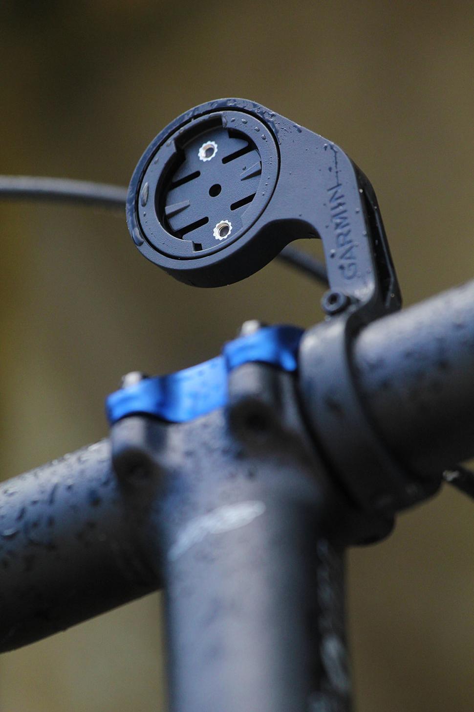
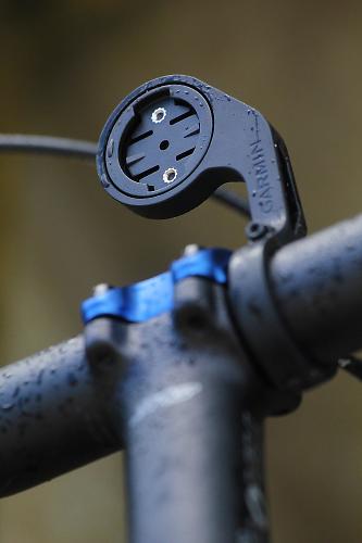
Edge 810 is rugged and waterproof, and has up to a 17-hour battery life. The touchscreen is easy to operate, even with a gloved finger and when wet. Mounting options include a new out-front mount for heads-up positioning and a standard quarter-turn mount.
Tell us some more about the technical aspects of the product?
Physical & Performance:
Unit dimensions, WxHxD 2.0" x 3.7" x 1.0" (5.1 x 9.3 x 2.5 cm)
Display size, WxH 1.4" x 2.2" (3.6 x 5.5 cm); 2.6" diag (6.6 cm)
Display resolution, WxH 160 x 240 pixels, touchscreen
Touchscreen Yes
Weight 3.5 oz (98.0 g)
Battery rechargeable lithium-ion
Battery life up to 17 hours
GPS-enabled Yes
High-sensitivity receiver Yes
Maps & Memory:
Basemap Yes
Ability to add maps Yes
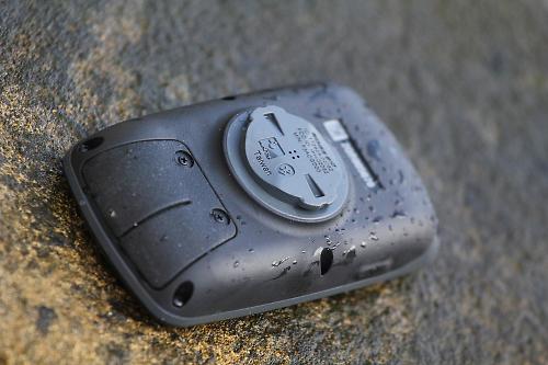
Accepts data cards microSD™ card (some versions include a City Navigator microSD card)
History up to 180 hours
Waypoints/favorites/locations 200
Routes Limited by memory space available
Features & Benefits:
Heart rate monitor Yes (Some versions)
Bike speed/cadence sensor Yes (Some versions)
Foot pod No
Automatic sync (automatically transfers data to your computer) No
Garmin Connect™ compatible (online community where you analyze, categorize and share data) Yes
Virtual Partner® (train against a digital person) Yes
Virtual Racer™ (compete against other activities) No
Courses (compete against previous activities) Yes
Auto Pause® (pauses and resumes timer based on speed) Yes
Auto Lap® (automatically starts a new lap) Yes
Auto Scroll (cycles through data pages during workout) Yes
Multi-sport (changes sport mode with a press of a button) No
Advanced workouts (create custom, goal-oriented workouts) Yes
Pace alert (triggers alarm if you vary from preset pace) Yes
Time/distance alert (triggers alarm when you reach goal) Yes
Vibration alert: (choose between alert tones and/or vibration alert) No
Interval training (set up exercise and rest intervals) Yes
Heart rate-based calorie computation Yes
Training Effect (measures impact of an activity on your aerobic fitness) No
Customizable screen(s) Yes
Barometric altimeter Yes
Unit-to-unit transfer (shares data wirelessly with similar units) No
Power meter compatible (displays power data from compatible 3rd party ANT+™-enabled power meters) Yes (records data approx. 1 per second)
Temperature (displays and records temperature while you ride) Yes
Sport watch No
Additional
Operating temp: -20°C to +55°C
Connected features via a smartphone: yes
GLONASS: no
Compatible with Garmin Connect™ Mobile: yes
Rate the product for quality of construction:
8/10
Rate the product for performance:
7/10
Great for some things, less so for others.
Rate the product for durability:
7/10
Waterproof and rugged, but easy to scratch in muddy conditions.
Rate the product for weight, if applicable:
9/10
Rate the product for value:
6/10
Expensive but not bad value, it'll be interesting to see whether the mapping gets cheaper with Ordnance Survey's restructuring.
Tell us how the product performed overall when used for its designed purpose
Mostly very well, with some provisos.
Tell us what you particularly liked about the product
Ease of use, web service, mapping.
Tell us what you particularly disliked about the product
Routing, bluetooth 2.1 chipset, screen resolution.
Did you enjoy using the product? Mostly, yes.
Would you consider buying the product? If you want a bar-mounted mapping GPS, this is the best one.
Would you recommend the product to a friend? Yes.
About the tester
Age: 40 Height: 190cm Weight: 102kg
I usually ride: whatever I'm testing... My best bike is: Genesis Equilibrium 853
I've been riding for: 10-20 years I ride: Every day I would class myself as: Experienced
I regularly do the following types of riding: commuting, club rides, sportives, general fitness riding, fixed/singlespeed, mtb, Mountain Bike Bog Snorkelling, track

Dave is a founding father of road.cc, having previously worked on Cycling Plus and What Mountain Bike magazines back in the day. He also writes about e-bikes for our sister publication ebiketips. He's won three mountain bike bog snorkelling World Championships, and races at the back of the third cats.
Latest Comments
- Cayo 2 sec ago
Firstly, my heart bleeds for Ms Collins. Google Maps shows Rules restaurant is halfway along Maiden Lane and that it would take a whole minute to...
- Cayo 17 min 57 sec ago
I'd be 100% in favour of the idea if it could stop people wearing their helmet tipped right back like some sort of Burberry-wearing chav in a...
- Phillman 37 min 19 sec ago
I desperately need a new tyre but cannot find one anywhere. The tyre says 20inch but the wheel is 22inch. Other tyres just don't fit. Can anyone...
- LordSandwich 43 min 16 sec ago
Your setup is a lot tidier than mine, for sure! 😅
- David9694 1 hour 50 min ago
Drivers : cyclists should pay Road Tax etc...
- ReflecToes 1 hour 53 min ago
A friend of mine created a rear light called tailgator technologies that has an accelorometer in it to get brighter when you are slowing down. My...
- ErnieC 2 hours 4 min ago
when does armed resistance become genocide?
- stonojnr 2 hours 16 min ago
well keep in mind the county council leading and proposing these active travel changes is Tory. so work that one out.
- Sredlums 3 hours 52 sec ago
What I don't understand is what is so hard to understand about the fact that higher/steeper stems bring the handlebars closer to you. If you only...


Add new comment
2 comments